Tibati geodata
Tibati (Adamaoua) is a populated place; located in Cameroon in Africa/Douala (GMT+1) time zone. With population of 35,589 people, there are 45 cities with bigger population in this country. Compared to other cities in Cameroon, 80.3% of cities are located further ↓South; 72.1% of cities are located further ←West and 72.1% of cities have lower elevation than Tibati. Note1


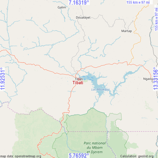
Tibati GPS coordinates[2]
6° 27' 54.144" North, 12° 37' 42.348" East
| Map corner | latitude | longitude |
|---|---|---|
| Upper-left | 7.16319°, | 11.92531° |
| Center: | 6.46504°, | 12.62843° |
| Lower-right: | 5.76592°, | 13.33156° |
| Map W x H: | 155.4×155.4 km | = 96.6×96.6mi |
| max Lat: | 12.57535° ⇑19.7% North |
| Tibati: | 6.46504° |
| min Lat: | ⇓80.3% South 2.35° |
| min Long | Tibati | max Long |
| 8.8724° | 12.62843° | 15.23288° |
| W 72.1%⇐ | ⇒27.9% E |
Elevation
Elevation of Tibati is 871 m = 2858 ft, and this is 197.1 m = 647 ft above average elevation for this country.
| Max E: |
1687 m = 5535 ft | 27.9% |
| Tibati | 871 m 2858 ft | |
| Avg. | 673.9 m = 2211 ft | |
Min E: |
1 m = 3 ft | 72.1% |
See also: Cameroon elevation on elevation.city.
Geographical zone
Tibati is located in North Torrid zone (between Equator and Tropic of Cancer). Distance of Equator is 718.8 km =446.6 mi to South.| Distance of | km | miles | from Tibati |
|---|---|---|---|
| North Pole | 9288.2 | 5771.4 | to North |
| Arctic Circle | 6682.3 | 4152.2 | to North |
| Tropic Cancer | 1887.1 | 1172.6 | to North |
| Equator | 718.8 | 446.6 | to South |


Nearby cities:
15 places around Tibati: (largest is in red/bold)
• Bankim
132.7 km =82.5 mi,  251°
251°
• Banyo
95.1 km =59.1 mi,  289°
289°
• Bélabo
185.8 km =115.5 mi,  156°
156°
• Bélel
209.6 km =130.2 mi,  71°
71°
• Bétaré Oya
187.4 km =116.4 mi,  120°
120°
• Foumban
208.1 km =129.3 mi, 246°
• Kontcha
172.6 km =107.2 mi,  345°
345°
• Meïganga
184.8 km =114.8 mi,  88°
88°
• Minta
210.1 km =130.6 mi,  174°
174°
• Nanga Eboko
200.2 km =124.4 mi,  188°
188°
• Ngaoundéré
142.6 km =88.6 mi,  47°
47°
• Ngoro
217.6 km =135.2 mi,  219°
219°
• Somié
132.1 km =82.1 mi,  269°
269°
• Tignère
100.3 km =62.3 mi,  1°
1°
• Yoko
109.2 km =67.9 mi,  198°
198°
Sources, notices
• [Note1] Compared only with cities in Cameroon existing in our database
• [Src1] Map data: © OpenStreetMap contributors (CC-BY-SA)
• [Src2] Other city data from geonames.org with taken over terms of usage.
• [Src3] Geographical zone / Annual Mean Temperature by Robert A. Rohde @ Wikipedia
