Tignère geodata
Tignère (Adamaoua) is a populated place; located in Cameroon in Africa/Douala (GMT+1) time zone. With population of 4,353 people, there are 107 cities with bigger population in this country. Compared to other cities in Cameroon, 85.2% of cities are located further ↓South; 73% of cities are located further ←West and 79.5% of cities have lower elevation than Tignère. Note1


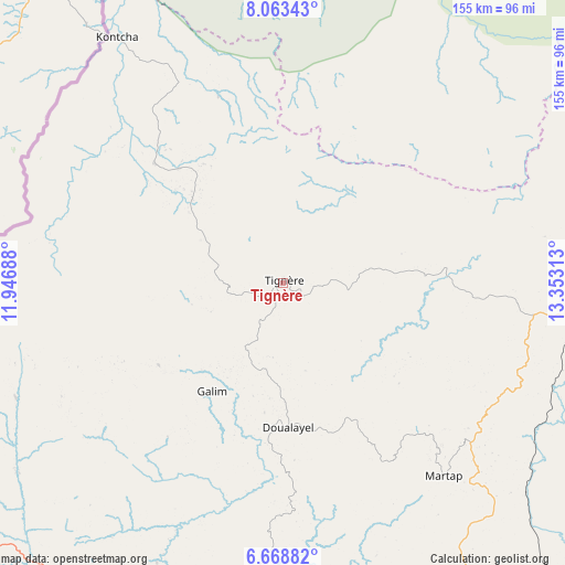
Tignère GPS coordinates[2]
7° 22' 0.012" North, 12° 39' 0" East
| Map corner | latitude | longitude |
|---|---|---|
| Upper-left | 8.06343°, | 11.94688° |
| Center: | 7.36667°, | 12.65° |
| Lower-right: | 6.66882°, | 13.35313° |
| Map W x H: | 155.1×155.1 km | = 96.4×96.4mi |
| max Lat: | 12.57535° ⇑14.8% North |
| Tignère: | 7.36667° |
| min Lat: | ⇓85.2% South 2.35° |
| min Long | Tignère | max Long |
| 8.8724° | 12.65° | 15.23288° |
| W 73%⇐ | ⇒27% E |
Elevation
Elevation of Tignère is 1104 m = 3622 ft, and this is 430.1 m = 1411 ft above average elevation for this country.
| Max E: |
1687 m = 5535 ft | 20.5% |
| Tignère | 1104 m 3622 ft | |
| Avg. | 673.9 m = 2211 ft | |
Min E: |
1 m = 3 ft | 79.5% |
See also: Cameroon elevation on elevation.city.
Geographical zone
Tignère is located in North Torrid zone (between Equator and Tropic of Cancer). Distance of Equator is 819.1 km =509 mi to South.| Distance of | km | miles | from Tignère |
|---|---|---|---|
| North Pole | 9188 | 5709.2 | to North |
| Arctic Circle | 6582.1 | 4089.9 | to North |
| Tropic Cancer | 1786.8 | 1110.3 | to North |
| Equator | 819.1 | 509 | to South |


Nearby cities:
15 places around Tignère: (largest is in red/bold)
• Bankim
191.7 km =119.1 mi,  221°
221°
• Banyo
114.7 km =71.3 mi,  233°
233°
• Bélel
199.8 km =124.1 mi,  100°
100°
• Djohong
233.8 km =145.3 mi, 104°
• Garoua
230.3 km =143.1 mi,  20°
20°
• Kontcha
81 km =50.3 mi,  325°
325°
• Lagdo
218.8 km =136 mi,  30°
30°
• Meïganga
205.2 km =127.5 mi,  117°
117°
• Ngaoundéré
103.2 km =64.1 mi,  92°
92°
• Poli
139.4 km =86.6 mi, 27°
• Rey Bouba
222.3 km =138.1 mi,  49°
49°
• Somié
168.1 km =104.5 mi, 233°
• Tcholliré
203.2 km =126.3 mi,  55°
55°
• Tibati
100.3 km =62.3 mi,  181°
181°
• Yoko
207.1 km =128.7 mi,  190°
190°
Sources, notices
• [Note1] Compared only with cities in Cameroon existing in our database
• [Src1] Map data: © OpenStreetMap contributors (CC-BY-SA)
• [Src2] Other city data from geonames.org with taken over terms of usage.
• [Src3] Geographical zone / Annual Mean Temperature by Robert A. Rohde @ Wikipedia
