Kontcha geodata
Kontcha (Adamaoua) is a populated place; located in Cameroon in Africa/Douala (GMT+1) time zone. With population of 8,018 people, there are 81 cities with bigger population in this country. Compared to other cities in Cameroon, 86.1% of cities are located further ↓South; 68.9% of cities are located further ←West and 69.7% of cities have higher elevation than Kontcha. Note1


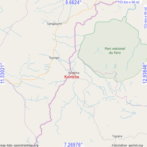
Kontcha GPS coordinates[2]
7° 58' 0.012" North, 12° 13' 59.988" East
| Map corner | latitude | longitude |
|---|---|---|
| Upper-left | 8.6624°, | 11.53021° |
| Center: | 7.96667°, | 12.23333° |
| Lower-right: | 7.26976°, | 12.93646° |
| Map W x H: | 154.8×154.9 km | = 96.2×96.3mi |
| max Lat: | 12.57535° ⇑13.9% North |
| Kontcha: | 7.96667° |
| min Lat: | ⇓86.1% South 2.35° |
| min Long | Kontcha | max Long |
| 8.8724° | 12.23333° | 15.23288° |
| W 68.9%⇐ | ⇒31.1% E |
Elevation
Elevation of Kontcha is 425 m = 1394 ft, and this is 248.9 m = 817 ft below average elevation for this country.
| Max E: |
1687 m = 5535 ft | 69.7% |
| Avg. | 673.9 m = 2211 ft | |
| Kontcha | 425 m = 1394 ft | |
Min E: |
1 m = 3 ft | 30.3% |
See also: Cameroon elevation on elevation.city.
Geographical zone
Kontcha is located in North Torrid zone (between Equator and Tropic of Cancer). Distance of Equator is 885.8 km =550.4 mi to South.| Distance of | km | miles | from Kontcha |
|---|---|---|---|
| North Pole | 9121.3 | 5667.7 | to North |
| Arctic Circle | 6515.4 | 4048.5 | to North |
| Tropic Cancer | 1720.1 | 1068.8 | to North |
| Equator | 885.8 | 550.4 | to South |


Nearby cities:
15 places around Kontcha: (largest is in red/bold)
• Bankim
224.9 km =139.7 mi,  201°
201°
• Banyo
142.9 km =88.8 mi, 198°
• Bélel
263.1 km =163.5 mi,  112°
112°
• Garoua
196 km =121.8 mi,  40°
40°
• Kumbo
261.7 km =162.6 mi,  221°
221°
• Lagdo
198.9 km =123.6 mi,  52°
52°
• Ngaoundéré
165 km =102.5 mi,  115°
115°
• Pitoa
210.4 km =130.7 mi, 41°
• Poli
124.5 km =77.4 mi,  62°
62°
• Rey Bouba
227.9 km =141.6 mi,  69°
69°
• Somié
189.5 km =117.7 mi,  207°
207°
• Tcholliré
218.6 km =135.8 mi,  77°
77°
• Tibati
172.6 km =107.2 mi,  165°
165°
• Tignère
81 km =50.3 mi,  145°
145°
• Yoko
270.7 km =168.2 mi,  178°
178°
Sources, notices
• [Note1] Compared only with cities in Cameroon existing in our database
• [Src1] Map data: © OpenStreetMap contributors (CC-BY-SA)
• [Src2] Other city data from geonames.org with taken over terms of usage.
• [Src3] Geographical zone / Annual Mean Temperature by Robert A. Rohde @ Wikipedia
