Gaojiacun geodata
Gaojiacun (Yunnan) is a seat of a fourth-order administrative division; located in China in Asia/Shanghai (GMT+8) time zone. In our database, there are 1268 cities with bigger population. Compared to other cities in China, 85.3% of cities are located further ↑North; 90.2% of cities are located further →East and 94.6% of cities have lower elevation than Gaojiacun. Note1


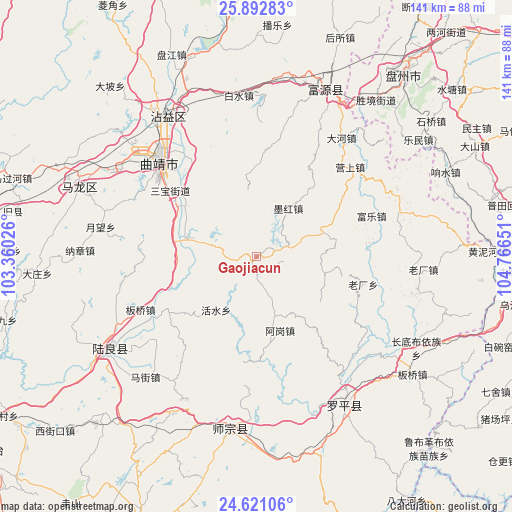
Gaojiacun GPS coordinates[2]
25° 15' 30.996" North, 104° 3' 48.168" East
| Map corner | latitude | longitude |
|---|---|---|
| Upper-left | 25.89283°, | 103.36026° |
| Center: | 25.25861°, | 104.06338° |
| Lower-right: | 24.62106°, | 104.76651° |
| Map W x H: | 141.4×141.4 km | = 87.9×87.9mi |
| max Lat: | 53.31946° ⇑85.3% North |
| Gaojiacun: | 25.25861° |
| min Lat: | ⇓14.7% South 18.22056° |
| min Long | Gaojiacun | max Long |
| 75.07348° | 104.06338° | 134.28917° |
| W 9.8%⇐ | ⇒90.2% E |
Elevation
Elevation of Gaojiacun is 1977 m = 6486 ft, and this is 1492.2 m = 4896 ft above average elevation for this country.
| Max E: |
5622 m = 18445 ft | 5.4% |
| Gaojiacun | 1977 m 6486 ft | |
| Avg. | 484.8 m = 1591 ft | |
Min E: |
-3 m = -10 ft | 94.6% |
See also: China elevation on elevation.city.
Geographical zone
Gaojiacun is located in North temperate zone (between Tropic of Cancer and the Arctic Circle). Distance of this Northern Tropic circle is 202.6 km =125.9 mi to South.| Distance of | km | miles | from Gaojiacun |
|---|---|---|---|
| North Pole | 7198.6 | 4473 | to North |
| Arctic Circle | 4592.7 | 2853.8 | to North |
| Tropic Cancer | 202.6 | 125.9 | to South |
| Equator | 2808.5 | 1745.1 | to South |


Nearby cities:
15 places around Gaojiacun: (largest is in red/bold)
• Beidacun Xiaozhai
83.7 km =52 mi,  237°
237°
• Chengfangqiao
60.1 km =37.3 mi,  337°
337°
• Danfeng
47.9 km =29.8 mi,  186°
186°
• Jianxincun
64.8 km =40.3 mi,  4°
4°
• Luoxiong
47.5 km =29.5 mi,  150°
150°
• Pingpo
36.3 km =22.6 mi,  301°
301°
• Qujing
37.6 km =23.4 mi,  311°
311°
• Rende
85.8 km =53.3 mi,  292°
292°
• Shilin
88.4 km =54.9 mi, 236°
• Tongquan
52.3 km =32.5 mi, 287°
• Weize
90.3 km =56.1 mi,  227°
227°
• Xiping
46.3 km =28.8 mi,  324°
324°
• Zhongshu
47.8 km =29.7 mi, 237°
• Zhongshu
87.8 km =54.6 mi,  199°
199°
• Zhong’an
48.5 km =30.1 mi,  20°
20°
Sources, notices
• [Note1] Compared only with cities in China existing in our database
• [Src1] Map data: © OpenStreetMap contributors (CC-BY-SA)
• [Src2] Other city data from geonames.org with taken over terms of usage.
• [Src3] Geographical zone / Annual Mean Temperature by Robert A. Rohde @ Wikipedia
