Danfeng geodata
Danfeng (Yunnan) is a seat of a third-order administrative division; located in China in Asia/Shanghai (GMT+8) time zone. In our database, there are 1268 cities with bigger population. Compared to other cities in China, 87.1% of cities are located further ↑North; 90.3% of cities are located further →East and 93.9% of cities have lower elevation than Danfeng. Note1


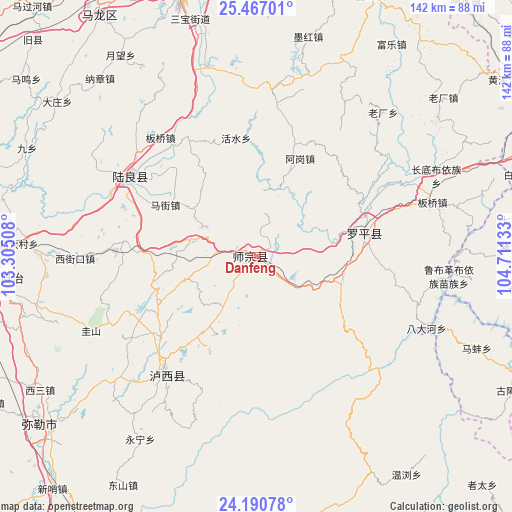
Danfeng GPS coordinates[2]
24° 49' 49.944" North, 104° 0' 29.52" East
| Map corner | latitude | longitude |
|---|---|---|
| Upper-left | 25.46701°, | 103.30508° |
| Center: | 24.83054°, | 104.0082° |
| Lower-right: | 24.19078°, | 104.71133° |
| Map W x H: | 141.9×141.9 km | = 88.2×88.2mi |
| max Lat: | 53.31946° ⇑87.1% North |
| Danfeng: | 24.83054° |
| min Lat: | ⇓12.9% South 18.22056° |
| min Long | Danfeng | max Long |
| 75.07348° | 104.0082° | 134.28917° |
| W 9.7%⇐ | ⇒90.3% E |
Elevation
Elevation of Danfeng is 1837 m = 6027 ft, and this is 1352.2 m = 4436 ft above average elevation for this country.
| Max E: |
5622 m = 18445 ft | 6.1% |
| Danfeng | 1837 m 6027 ft | |
| Avg. | 484.8 m = 1591 ft | |
Min E: |
-3 m = -10 ft | 93.9% |
See also: China elevation on elevation.city.
Geographical zone
Danfeng is located in North temperate zone (between Tropic of Cancer and the Arctic Circle). Distance of this Northern Tropic circle is 155 km =96.3 mi to South.| Distance of | km | miles | from Danfeng |
|---|---|---|---|
| North Pole | 7246.2 | 4502.6 | to North |
| Arctic Circle | 4640.3 | 2883.3 | to North |
| Tropic Cancer | 155 | 96.3 | to South |
| Equator | 2760.9 | 1715.5 | to South |


Nearby cities:
15 places around Danfeng: (largest is in red/bold)
• Beidacun Xiaozhai
65.5 km =40.7 mi,  272°
272°
• Dake
81.3 km =50.5 mi,  252°
252°
• Gaojiacun
47.9 km =29.8 mi,  6°
6°
• Huakoulongtan
70.4 km =43.7 mi,  238°
238°
• Lufu
75.3 km =46.8 mi,  264°
264°
• Luoxiong
29.3 km =18.2 mi,  77°
77°
• Majie
77.4 km =48.1 mi, 258°
• Miyang
74.3 km =46.2 mi,  230°
230°
• Pingpo
71.2 km =44.2 mi,  338°
338°
• Qujing
76 km =47.2 mi, 342°
• Shilin
68.2 km =42.4 mi, 268°
• Tongquan
77.4 km =48.1 mi,  324°
324°
• Weize
62.4 km =38.8 mi, 257°
• Zhongshu
41.1 km =25.5 mi,  302°
302°
• Zhongshu
42.6 km =26.5 mi,  214°
214°
Sources, notices
• [Note1] Compared only with cities in China existing in our database
• [Src1] Map data: © OpenStreetMap contributors (CC-BY-SA)
• [Src2] Other city data from geonames.org with taken over terms of usage.
• [Src3] Geographical zone / Annual Mean Temperature by Robert A. Rohde @ Wikipedia
