Binhe geodata
Binhe (Ningxia Hui Autonomous Region) is a seat of a third-order administrative division; located in China in Asia/Shanghai (GMT+8) time zone. In our database, there are 1268 cities with bigger population. Compared to other cities in China, 80.3% of cities are located further ↓South; 88.8% of cities are located further →East and 88.5% of cities have lower elevation than Binhe. Note1


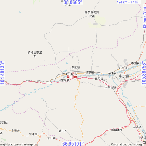
Binhe GPS coordinates[2]
37° 30' 39.024" North, 105° 11' 4.02" East
| Map corner | latitude | longitude |
|---|---|---|
| Upper-left | 38.0665°, | 104.48133° |
| Center: | 37.51084°, | 105.18445° |
| Lower-right: | 36.95101°, | 105.88758° |
| Map W x H: | 124×124 km | = 77.1×77.1mi |
| max Lat: | 53.31946° ⇑19.7% North |
| Binhe: | 37.51084° |
| min Lat: | ⇓80.3% South 18.22056° |
| min Long | Binhe | max Long |
| 75.07348° | 105.18445° | 134.28917° |
| W 11.2%⇐ | ⇒88.8% E |
Elevation
Elevation of Binhe is 1228 m = 4029 ft, and this is 743.2 m = 2438 ft above average elevation for this country.
| Max E: |
5622 m = 18445 ft | 11.5% |
| Binhe | 1228 m 4029 ft | |
| Avg. | 484.8 m = 1591 ft | |
Min E: |
-3 m = -10 ft | 88.5% |
See also: China elevation on elevation.city.
Geographical zone
Binhe is located in North temperate zone (between Tropic of Cancer and the Arctic Circle). Distance of this Northern Tropic circle is 1564.9 km =972.4 mi to South.| Distance of | km | miles | from Binhe |
|---|---|---|---|
| North Pole | 5836.2 | 3626.4 | to North |
| Arctic Circle | 3230.4 | 2007.3 | to North |
| Tropic Cancer | 1564.9 | 972.4 | to South |
| Equator | 4170.8 | 2591.6 | to South |


Nearby cities:
15 places around Binhe: (largest is in red/bold)
• Dongta
120 km =74.6 mi,  58°
58°
• Hongsipu
78.3 km =48.7 mi,  99°
99°
• Liwang
124.1 km =77.1 mi,  139°
139°
• Luochuan
123.5 km =76.7 mi, 144°
• Ning’an
43.4 km =27 mi,  91°
91°
• Sanhe
112.7 km =70 mi,  159°
159°
• Shengli
103.4 km =64.2 mi, 59°
• Wulan
114.1 km =70.9 mi,  202°
202°
• Wuzhong
103.9 km =64.6 mi, 59°
• Xingpinglu
93.1 km =57.8 mi, 200°
• Yanghe
126.5 km =78.6 mi,  47°
47°
• Yanglu
129.1 km =80.2 mi, 138°
• Yitiaoshan
106.9 km =66.4 mi,  248°
248°
• Yuhai
86.9 km =54 mi,  132°
132°
• Zhongwei
0.6 km =0.4 mi,  84°
84°
Sources, notices
• [Note1] Compared only with cities in China existing in our database
• [Src1] Map data: © OpenStreetMap contributors (CC-BY-SA)
• [Src2] Other city data from geonames.org with taken over terms of usage.
• [Src3] Geographical zone / Annual Mean Temperature by Robert A. Rohde @ Wikipedia
