Dongta geodata
Dongta (Ningxia Hui Autonomous Region) is a seat of a third-order administrative division; located in China in Asia/Shanghai (GMT+8) time zone. In our database, there are 1268 cities with bigger population. Compared to other cities in China, 81.1% of cities are located further ↓South; 85.6% of cities are located further →East and 87.1% of cities have lower elevation than Dongta. Note1


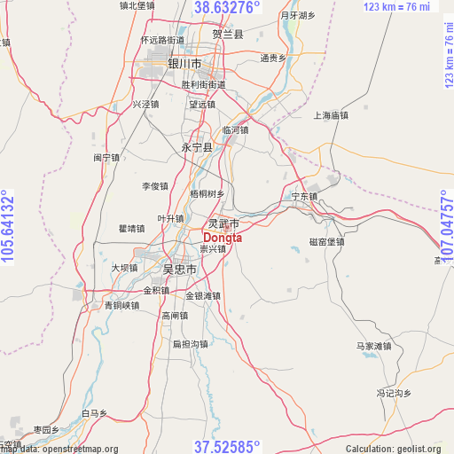
Dongta GPS coordinates[2]
38° 4' 53.04" North, 106° 20' 39.984" East
| Map corner | latitude | longitude |
|---|---|---|
| Upper-left | 38.63276°, | 105.64132° |
| Center: | 38.0814°, | 106.34444° |
| Lower-right: | 37.52585°, | 107.04757° |
| Map W x H: | 123.1×123.1 km | = 76.5×76.5mi |
| max Lat: | 53.31946° ⇑18.9% North |
| Dongta: | 38.0814° |
| min Lat: | ⇓81.1% South 18.22056° |
| min Long | Dongta | max Long |
| 75.07348° | 106.34444° | 134.28917° |
| W 14.4%⇐ | ⇒85.6% E |
Elevation
Elevation of Dongta is 1122 m = 3681 ft, and this is 637.2 m = 2091 ft above average elevation for this country.
| Max E: |
5622 m = 18445 ft | 12.9% |
| Dongta | 1122 m 3681 ft | |
| Avg. | 484.8 m = 1591 ft | |
Min E: |
-3 m = -10 ft | 87.1% |
See also: China elevation on elevation.city.
Geographical zone
Dongta is located in North temperate zone (between Tropic of Cancer and the Arctic Circle). Distance of this Northern Tropic circle is 1628.3 km =1011.8 mi to South.| Distance of | km | miles | from Dongta |
|---|---|---|---|
| North Pole | 5772.8 | 3587.1 | to North |
| Arctic Circle | 3166.9 | 1967.8 | to North |
| Tropic Cancer | 1628.3 | 1011.8 | to South |
| Equator | 4234.3 | 2631.1 | to South |


Nearby cities:
15 places around Dongta: (largest is in red/bold)
• Bayan Hot
102.7 km =63.8 mi,  325°
325°
• Binhe
120 km =74.6 mi,  238°
238°
• Dawukou
106.9 km =66.4 mi,  2°
2°
• Dingbian
122.5 km =76.1 mi,  116°
116°
• Hongsipu
79.9 km =49.6 mi,  198°
198°
• Huamachi
98.5 km =61.2 mi,  109°
109°
• Ning’an
87.5 km =54.4 mi,  222°
222°
• Oljoq
99.5 km =61.8 mi,  83°
83°
• Pingluo Chengguanzhen
93 km =57.8 mi,  10°
10°
• Shengli
16.9 km =10.5 mi,  230°
230°
• Wuzhong
16.4 km =10.2 mi, 230°
• Xigang
52.4 km =32.6 mi, 0°
• Yanghe
23.5 km =14.6 mi,  338°
338°
• Yinchuan
43.4 km =27 mi,  351°
351°
• Zhongwei
119.6 km =74.3 mi, 237°
Sources, notices
• [Note1] Compared only with cities in China existing in our database
• [Src1] Map data: © OpenStreetMap contributors (CC-BY-SA)
• [Src2] Other city data from geonames.org with taken over terms of usage.
• [Src3] Geographical zone / Annual Mean Temperature by Robert A. Rohde @ Wikipedia
