Zagunao geodata
Zagunao (Sichuan) is a seat of a third-order administrative division; located in China in Asia/Shanghai (GMT+8) time zone. In our database, there are 1268 cities with bigger population. Compared to other cities in China, 58% of cities are located further ↓South; 91.3% of cities are located further →East and 93.8% of cities have lower elevation than Zagunao. Note1


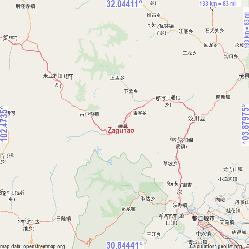
Zagunao GPS coordinates[2]
31° 26' 46.248" North, 103° 10' 35.832" East
| Map corner | latitude | longitude |
|---|---|---|
| Upper-left | 32.04411°, | 102.4735° |
| Center: | 31.44618°, | 103.17662° |
| Lower-right: | 30.84441°, | 103.87975° |
| Map W x H: | 133.4×133.4 km | = 82.9×82.9mi |
| max Lat: | 53.31946° ⇑42% North |
| Zagunao: | 31.44618° |
| min Lat: | ⇓58% South 18.22056° |
| min Long | Zagunao | max Long |
| 75.07348° | 103.17662° | 134.28917° |
| W 8.7%⇐ | ⇒91.3% E |
Elevation
Elevation of Zagunao is 1826 m = 5991 ft, and this is 1341.2 m = 4400 ft above average elevation for this country.
| Max E: |
5622 m = 18445 ft | 6.2% |
| Zagunao | 1826 m 5991 ft | |
| Avg. | 484.8 m = 1591 ft | |
Min E: |
-3 m = -10 ft | 93.8% |
See also: China elevation on elevation.city.
Geographical zone
Zagunao is located in North temperate zone (between Tropic of Cancer and the Arctic Circle). Distance of this Northern Tropic circle is 890.6 km =553.4 mi to South.| Distance of | km | miles | from Zagunao |
|---|---|---|---|
| North Pole | 6510.6 | 4045.5 | to North |
| Arctic Circle | 3904.7 | 2426.3 | to North |
| Tropic Cancer | 890.6 | 553.4 | to South |
| Equator | 3496.5 | 2172.6 | to South |


Nearby cities:
15 places around Zagunao: (largest is in red/bold)
• Barkam
103.6 km =64.4 mi,  299°
299°
• Fangting
100.5 km =62.4 mi,  110°
110°
• Fengyi
69.4 km =43.1 mi,  67°
67°
• Guangsheng
91.7 km =57 mi,  149°
149°
• Jiannan
97.4 km =60.5 mi,  96°
96°
• Jinchuan
106.1 km =65.9 mi,  271°
271°
• Liucheng
104.2 km =64.7 mi,  142°
142°
• Luhua
71.3 km =44.3 mi,  345°
345°
• Meixing
92.2 km =57.3 mi,  237°
237°
• Pitong
97.6 km =60.6 mi, 136°
• Se’ergu
59.3 km =36.8 mi,  22°
22°
• Tianpeng
88.7 km =55.1 mi,  125°
125°
• Weizhou
39.1 km =24.3 mi,  82°
82°
• Xipu
107.6 km =66.9 mi, 135°
• Zitong
91.9 km =57.1 mi, 147°
Sources, notices
• [Note1] Compared only with cities in China existing in our database
• [Src1] Map data: © OpenStreetMap contributors (CC-BY-SA)
• [Src2] Other city data from geonames.org with taken over terms of usage.
• [Src3] Geographical zone / Annual Mean Temperature by Robert A. Rohde @ Wikipedia
