Luhua geodata
Luhua (Sichuan) is a seat of a third-order administrative division; located in China in Asia/Shanghai (GMT+8) time zone. In our database, there are 1268 cities with bigger population. Compared to other cities in China, 61.6% of cities are located further ↓South; 91.5% of cities are located further →East and 95.6% of cities have lower elevation than Luhua. Note1


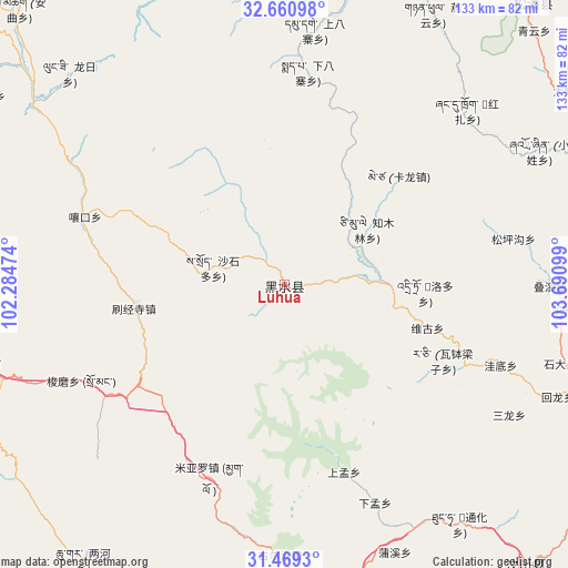
Luhua GPS coordinates[2]
32° 4' 1.488" North, 102° 59' 16.296" East
| Map corner | latitude | longitude |
|---|---|---|
| Upper-left | 32.66098°, | 102.28474° |
| Center: | 32.06708°, | 102.98786° |
| Lower-right: | 31.4693°, | 103.69099° |
| Map W x H: | 132.5×132.5 km | = 82.3×82.3mi |
| max Lat: | 53.31946° ⇑38.4% North |
| Luhua: | 32.06708° |
| min Lat: | ⇓61.6% South 18.22056° |
| min Long | Luhua | max Long |
| 75.07348° | 102.98786° | 134.28917° |
| W 8.5%⇐ | ⇒91.5% E |
Elevation
Elevation of Luhua is 2346 m = 7697 ft, and this is 1861.2 m = 6106 ft above average elevation for this country.
| Max E: |
5622 m = 18445 ft | 4.4% |
| Luhua | 2346 m 7697 ft | |
| Avg. | 484.8 m = 1591 ft | |
Min E: |
-3 m = -10 ft | 95.6% |
See also: China elevation on elevation.city.
Geographical zone
Luhua is located in North temperate zone (between Tropic of Cancer and the Arctic Circle). Distance of this Northern Tropic circle is 959.6 km =596.3 mi to South.| Distance of | km | miles | from Luhua |
|---|---|---|---|
| North Pole | 6441.5 | 4002.6 | to North |
| Arctic Circle | 3835.6 | 2383.3 | to North |
| Tropic Cancer | 959.6 | 596.3 | to South |
| Equator | 3565.5 | 2215.5 | to South |


Nearby cities:
15 places around Luhua: (largest is in red/bold)
• Barkam
74.7 km =46.4 mi,  255°
255°
• Fengyi
92.2 km =57.3 mi,  117°
117°
• Jiannan
139.7 km =86.8 mi,  125°
125°
• Jinchuan
109.7 km =68.2 mi,  233°
233°
• Jin’an
85.6 km =53.2 mi,  41°
41°
• Long’an
149.8 km =93.1 mi,  75°
75°
• Maikun
148.9 km =92.5 mi,  309°
309°
• Meixing
132.8 km =82.5 mi,  206°
206°
• Qiongxi
90.8 km =56.4 mi,  332°
332°
• Rong’an
140.2 km =87.1 mi,  291°
291°
• Se’ergu
43.1 km =26.8 mi,  109°
109°
• Tianpeng
150.2 km =93.3 mi,  143°
143°
• Weizhou
85.2 km =52.9 mi, 138°
• Yongchang
144 km =89.5 mi, 108°
• Zagunao
71.3 km =44.3 mi,  165°
165°
Sources, notices
• [Note1] Compared only with cities in China existing in our database
• [Src1] Map data: © OpenStreetMap contributors (CC-BY-SA)
• [Src2] Other city data from geonames.org with taken over terms of usage.
• [Src3] Geographical zone / Annual Mean Temperature by Robert A. Rohde @ Wikipedia
