Jinchuan geodata
Jinchuan (Sichuan) is a seat of a third-order administrative division; located in China in Asia/Shanghai (GMT+8) time zone. In our database, there are 1268 cities with bigger population. Compared to other cities in China, 58.2% of cities are located further ↓South; 92.8% of cities are located further →East and 95.2% of cities have lower elevation than Jinchuan. Note1


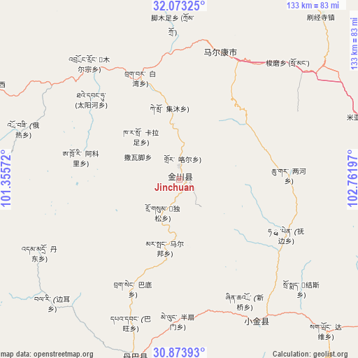
Jinchuan GPS coordinates[2]
31° 28' 31.836" North, 102° 3' 31.824" East
| Map corner | latitude | longitude |
|---|---|---|
| Upper-left | 32.07325°, | 101.35572° |
| Center: | 31.47551°, | 102.05884° |
| Lower-right: | 30.87393°, | 102.76197° |
| Map W x H: | 133.4×133.4 km | = 82.9×82.9mi |
| max Lat: | 53.31946° ⇑41.8% North |
| Jinchuan: | 31.47551° |
| min Lat: | ⇓58.2% South 18.22056° |
| min Long | Jinchuan | max Long |
| 75.07348° | 102.05884° | 134.28917° |
| W 7.2%⇐ | ⇒92.8% E |
Elevation
Elevation of Jinchuan is 2199 m = 7215 ft, and this is 1714.2 m = 5624 ft above average elevation for this country.
| Max E: |
5622 m = 18445 ft | 4.8% |
| Jinchuan | 2199 m 7215 ft | |
| Avg. | 484.8 m = 1591 ft | |
Min E: |
-3 m = -10 ft | 95.2% |
See also: China elevation on elevation.city.
Geographical zone
Jinchuan is located in North temperate zone (between Tropic of Cancer and the Arctic Circle). Distance of this Northern Tropic circle is 893.8 km =555.4 mi to South.| Distance of | km | miles | from Jinchuan |
|---|---|---|---|
| North Pole | 6507.3 | 4043.4 | to North |
| Arctic Circle | 3901.4 | 2424.2 | to North |
| Tropic Cancer | 893.8 | 555.4 | to South |
| Equator | 3499.7 | 2174.6 | to South |


Nearby cities:
15 places around Jinchuan: (largest is in red/bold)
• Barkam
49.7 km =30.9 mi,  17°
17°
• Kehe
139.3 km =86.6 mi,  333°
333°
• Kuasha
136.4 km =84.8 mi,  338°
338°
• Luhua
109.7 km =68.2 mi,  53°
53°
• Maikun
162.1 km =100.7 mi,  349°
349°
• Meixing
60.2 km =37.4 mi,  151°
151°
• Muping
142.3 km =88.4 mi, 149°
• Qiongxi
153.4 km =95.3 mi, 17°
• Rong’an
124.9 km =77.6 mi, 339°
• Se’ergu
138.6 km =86.1 mi,  68°
68°
• Weizhou
144.7 km =89.9 mi,  89°
89°
• Xianshui
103.7 km =64.4 mi,  238°
238°
• Xindou
131.2 km =81.5 mi,  266°
266°
• Zagunao
106.1 km =65.9 mi, 91°
• Zhanggu
69.4 km =43.1 mi,  193°
193°
Sources, notices
• [Note1] Compared only with cities in China existing in our database
• [Src1] Map data: © OpenStreetMap contributors (CC-BY-SA)
• [Src2] Other city data from geonames.org with taken over terms of usage.
• [Src3] Geographical zone / Annual Mean Temperature by Robert A. Rohde @ Wikipedia
