Guandian geodata
Guandian (Guizhou) is a seat of a fourth-order administrative division; located in China in Asia/Shanghai (GMT+8) time zone. With population of 548 people, there are 1259 cities with bigger population in this country. Compared to other cities in China, 71.5% of cities are located further ↑North; 84.8% of cities are located further →East and 77.6% of cities have lower elevation than Guandian. Note1


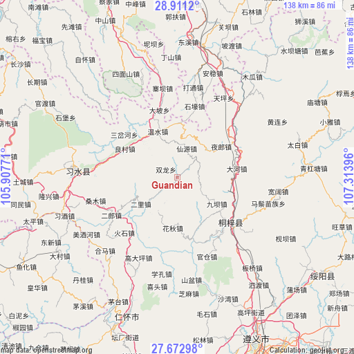
Guandian GPS coordinates[2]
28° 17' 38.004" North, 106° 36' 38.988" East
| Map corner | latitude | longitude |
|---|---|---|
| Upper-left | 28.9112°, | 105.90771° |
| Center: | 28.29389°, | 106.61083° |
| Lower-right: | 27.67298°, | 107.31396° |
| Map W x H: | 137.7×137.7 km | = 85.6×85.6mi |
| max Lat: | 53.31946° ⇑71.5% North |
| Guandian: | 28.29389° |
| min Lat: | ⇓28.5% South 18.22056° |
| min Long | Guandian | max Long |
| 75.07348° | 106.61083° | 134.28917° |
| W 15.2%⇐ | ⇒84.8% E |
Elevation
Elevation of Guandian is 596 m = 1955 ft, and this is 111.2 m = 365 ft above average elevation for this country.
| Max E: |
5622 m = 18445 ft | 22.4% |
| Guandian | 596 m 1955 ft | |
| Avg. | 484.8 m = 1591 ft | |
Min E: |
-3 m = -10 ft | 77.6% |
See also: China elevation on elevation.city.
Geographical zone
Guandian is located in North temperate zone (between Tropic of Cancer and the Arctic Circle). Distance of this Northern Tropic circle is 540.1 km =335.6 mi to South.| Distance of | km | miles | from Guandian |
|---|---|---|---|
| North Pole | 6861.1 | 4263.3 | to North |
| Arctic Circle | 4255.2 | 2644.1 | to North |
| Tropic Cancer | 540.1 | 335.6 | to South |
| Equator | 3146 | 1954.8 | to South |


Nearby cities:
15 places around Guandian: (largest is in red/bold)
• Chumi
22.7 km =14.1 mi,  107°
107°
• Dahe
22.3 km =13.9 mi,  81°
81°
• Datong
34.1 km =21.2 mi,  9°
9°
• Guancang
30.4 km =18.9 mi,  160°
160°
• Huaqiu
19.7 km =12.2 mi,  182°
182°
• Liangcunchang
22.1 km =13.7 mi,  304°
304°
• Liziba
18.3 km =11.4 mi,  125°
125°
• Loushanguan
27.1 km =16.8 mi, 130°
• Sanchahe
28.6 km =17.8 mi,  321°
321°
• Sangmu
34.6 km =21.5 mi,  255°
255°
• Wenshui
19.3 km =12 mi,  334°
334°
• Xianyuan
10 km =6.2 mi,  353°
353°
• Xinzhan
26.3 km =16.3 mi,  66°
66°
• Yelang
20.4 km =12.7 mi,  53°
53°
• Yong’an
20.8 km =12.9 mi,  241°
241°
Sources, notices
• [Note1] Compared only with cities in China existing in our database
• [Src1] Map data: © OpenStreetMap contributors (CC-BY-SA)
• [Src2] Other city data from geonames.org with taken over terms of usage.
• [Src3] Geographical zone / Annual Mean Temperature by Robert A. Rohde @ Wikipedia
