Yangping geodata
Yangping (Guizhou) is a populated place; located in China in Asia/Shanghai (GMT+8) time zone. With population of 910 people, there are 1195 cities with bigger population in this country. Compared to other cities in China, 78% of cities are located further ↑North; 77.2% of cities are located further →East and 71.1% of cities have lower elevation than Yangping. Note1


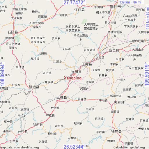
Yangping GPS coordinates[2]
27° 9' 2.988" North, 108° 47' 53.016" East
| Map corner | latitude | longitude |
|---|---|---|
| Upper-left | 27.77472°, | 108.09494° |
| Center: | 27.15083°, | 108.79806° |
| Lower-right: | 26.52344°, | 109.50119° |
| Map W x H: | 139.1×139.1 km | = 86.4×86.4mi |
| max Lat: | 53.31946° ⇑78% North |
| Yangping: | 27.15083° |
| min Lat: | ⇓22% South 18.22056° |
| min Long | Yangping | max Long |
| 75.07348° | 108.79806° | 134.28917° |
| W 22.8%⇐ | ⇒77.2% E |
Elevation
Elevation of Yangping is 431 m = 1414 ft, and this is 53.8 m = 177 ft below average elevation for this country.
| Max E: |
5622 m = 18445 ft | 28.9% |
| Avg. | 484.8 m = 1591 ft | |
| Yangping | 431 m = 1414 ft | |
Min E: |
-3 m = -10 ft | 71.1% |
See also: China elevation on elevation.city.
Geographical zone
Yangping is located in North temperate zone (between Tropic of Cancer and the Arctic Circle). Distance of this Northern Tropic circle is 413 km =256.6 mi to South.| Distance of | km | miles | from Yangping |
|---|---|---|---|
| North Pole | 6988.2 | 4342.3 | to North |
| Arctic Circle | 4382.3 | 2723 | to North |
| Tropic Cancer | 413 | 256.6 | to South |
| Equator | 3018.9 | 1875.9 | to South |


Nearby cities:
15 places around Yangping: (largest is in red/bold)
• Bangdong
43.1 km =26.8 mi,  116°
116°
• Duping
39.6 km =24.6 mi,  292°
292°
• Gongxi
36.2 km =22.5 mi,  96°
96°
• Jiaoxi
25.1 km =15.6 mi,  253°
253°
• Liangsan
17.5 km =10.9 mi,  112°
112°
• Minhe
43.2 km =26.8 mi,  356°
356°
• Qinglang
7.1 km =4.4 mi, 245°
• Runsong
43 km =26.7 mi,  136°
136°
• Siyang
8.6 km =5.3 mi,  322°
322°
• Xinhuang
41.4 km =25.7 mi,  53°
53°
• Xuedong
16.6 km =10.3 mi,  160°
160°
• Yangliugou
34.5 km =21.4 mi, 359°
• Yongxi
48.7 km =30.3 mi, 251°
• Zhongzhai
46.8 km =29.1 mi,  83°
83°
• Zhujiachang
26.8 km =16.7 mi,  31°
31°
Sources, notices
• [Note1] Compared only with cities in China existing in our database
• [Src1] Map data: © OpenStreetMap contributors (CC-BY-SA)
• [Src2] Other city data from geonames.org with taken over terms of usage.
• [Src3] Geographical zone / Annual Mean Temperature by Robert A. Rohde @ Wikipedia
