Yangliugou geodata
Yangliugou (Guizhou) is a populated place; located in China in Asia/Shanghai (GMT+8) time zone. With population of 523 people, there are 1262 cities with bigger population in this country. Compared to other cities in China, 76.7% of cities are located further ↑North; 77.2% of cities are located further →East and 76.5% of cities have lower elevation than Yangliugou. Note1


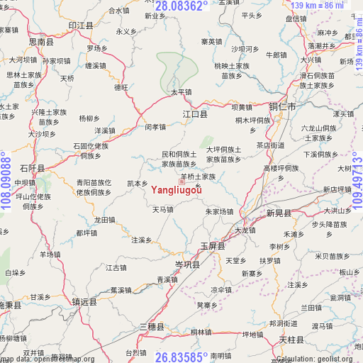
Yangliugou GPS coordinates[2]
27° 27' 41.4" North, 108° 47' 38.4" East
| Map corner | latitude | longitude |
|---|---|---|
| Upper-left | 28.08362°, | 108.09088° |
| Center: | 27.4615°, | 108.794° |
| Lower-right: | 26.83585°, | 109.49713° |
| Map W x H: | 138.7×138.7 km | = 86.2×86.2mi |
| max Lat: | 53.31946° ⇑76.7% North |
| Yangliugou: | 27.4615° |
| min Lat: | ⇓23.3% South 18.22056° |
| min Long | Yangliugou | max Long |
| 75.07348° | 108.794° | 134.28917° |
| W 22.8%⇐ | ⇒77.2% E |
Elevation
Elevation of Yangliugou is 560 m = 1837 ft, and this is 75.2 m = 247 ft above average elevation for this country.
| Max E: |
5622 m = 18445 ft | 23.5% |
| Yangliugou | 560 m 1837 ft | |
| Avg. | 484.8 m = 1591 ft | |
Min E: |
-3 m = -10 ft | 76.5% |
See also: China elevation on elevation.city.
Geographical zone
Yangliugou is located in North temperate zone (between Tropic of Cancer and the Arctic Circle). Distance of this Northern Tropic circle is 447.5 km =278.1 mi to South.| Distance of | km | miles | from Yangliugou |
|---|---|---|---|
| North Pole | 6953.6 | 4320.8 | to North |
| Arctic Circle | 4347.7 | 2701.5 | to North |
| Tropic Cancer | 447.5 | 278.1 | to South |
| Equator | 3053.4 | 1897.3 | to South |


Nearby cities:
15 places around Yangliugou: (largest is in red/bold)
• Bahuang
36.1 km =22.4 mi,  37°
37°
• Bapan
31.3 km =19.4 mi,  27°
27°
• Chadian
36 km =22.4 mi,  68°
68°
• Duping
41.1 km =25.5 mi,  241°
241°
• Liangsan
44.3 km =27.5 mi,  158°
158°
• Minhe
8.8 km =5.5 mi,  347°
347°
• Mulong
40.3 km =25 mi, 42°
• Qinglang
37.9 km =23.5 mi,  189°
189°
• Siyang
28.2 km =17.5 mi, 189°
• Tongren
47.9 km =29.8 mi,  53°
53°
• Wanshan
41.2 km =25.6 mi,  80°
80°
• Xinhuang
34.9 km =21.7 mi,  106°
106°
• Yangping
34.5 km =21.4 mi,  179°
179°
• Youyupu
35.1 km =21.8 mi, 73°
• Zhujiachang
18.3 km =11.4 mi,  129°
129°
Sources, notices
• [Note1] Compared only with cities in China existing in our database
• [Src1] Map data: © OpenStreetMap contributors (CC-BY-SA)
• [Src2] Other city data from geonames.org with taken over terms of usage.
• [Src3] Geographical zone / Annual Mean Temperature by Robert A. Rohde @ Wikipedia
