Siyang geodata
Siyang (Guizhou) is a seat of a third-order administrative division; located in China in Asia/Shanghai (GMT+8) time zone. In our database, there are 1268 cities with bigger population. Compared to other cities in China, 77.7% of cities are located further ↑North; 77.5% of cities are located further →East and 69.7% of cities have lower elevation than Siyang. Note1


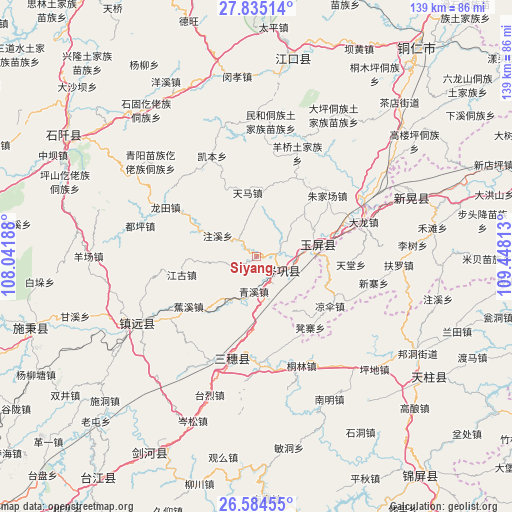
Siyang GPS coordinates[2]
27° 12' 41.76" North, 108° 44' 42" East
| Map corner | latitude | longitude |
|---|---|---|
| Upper-left | 27.83514°, | 108.04188° |
| Center: | 27.2116°, | 108.745° |
| Lower-right: | 26.58455°, | 109.44813° |
| Map W x H: | 139.1×139.1 km | = 86.4×86.4mi |
| max Lat: | 53.31946° ⇑77.7% North |
| Siyang: | 27.2116° |
| min Lat: | ⇓22.3% South 18.22056° |
| min Long | Siyang | max Long |
| 75.07348° | 108.745° | 134.28917° |
| W 22.5%⇐ | ⇒77.5% E |
Elevation
Elevation of Siyang is 405 m = 1329 ft, and this is 79.8 m = 262 ft below average elevation for this country.
| Max E: |
5622 m = 18445 ft | 30.3% |
| Avg. | 484.8 m = 1591 ft | |
| Siyang | 405 m = 1329 ft | |
Min E: |
-3 m = -10 ft | 69.7% |
See also: China elevation on elevation.city.
Geographical zone
Siyang is located in North temperate zone (between Tropic of Cancer and the Arctic Circle). Distance of this Northern Tropic circle is 419.7 km =260.8 mi to South.| Distance of | km | miles | from Siyang |
|---|---|---|---|
| North Pole | 6981.4 | 4338 | to North |
| Arctic Circle | 4375.5 | 2718.8 | to North |
| Tropic Cancer | 419.7 | 260.8 | to South |
| Equator | 3025.6 | 1880 | to South |


Nearby cities:
15 places around Siyang: (largest is in red/bold)
• Bangdong
50.9 km =31.6 mi,  121°
121°
• Duping
32.5 km =20.2 mi,  284°
284°
• Gongxi
42.7 km =26.5 mi,  104°
104°
• Jiaoxi
23.4 km =14.5 mi,  233°
233°
• Liangsan
25.2 km =15.7 mi, 121°
• Minhe
36.5 km =22.7 mi,  4°
4°
• Qinglang
9.7 km =6 mi,  187°
187°
• Runsong
51.6 km =32.1 mi,  137°
137°
• Xinhuang
42.4 km =26.3 mi,  64°
64°
• Xuedong
24.8 km =15.4 mi,  154°
154°
• Yangliugou
28.2 km =17.5 mi,  9°
9°
• Yangping
8.6 km =5.3 mi, 142°
• Yongxi
46.6 km =29 mi,  241°
241°
• Zhongzhai
51.8 km =32.2 mi,  92°
92°
• Zhujiachang
25.1 km =15.6 mi,  49°
49°
Sources, notices
• [Note1] Compared only with cities in China existing in our database
• [Src1] Map data: © OpenStreetMap contributors (CC-BY-SA)
• [Src2] Other city data from geonames.org with taken over terms of usage.
• [Src3] Geographical zone / Annual Mean Temperature by Robert A. Rohde @ Wikipedia
