Magui geodata
Magui (Guangdong) is a seat of a fourth-order administrative division; located in China in Asia/Urumqi (GMT+6) time zone. In our database, there are 1268 cities with bigger population. Compared to other cities in China, 96.9% of cities are located further ↑North; 65.8% of cities are located further →East and 72.2% of cities have lower elevation than Magui. Note1


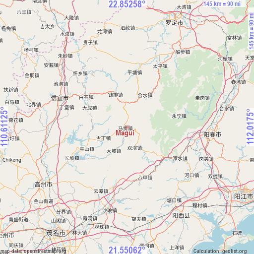
Magui GPS coordinates[2]
22° 12' 11.196" North, 111° 18' 51.732" East
| Map corner | latitude | longitude |
|---|---|---|
| Upper-left | 22.85258°, | 110.61125° |
| Center: | 22.20311°, | 111.31437° |
| Lower-right: | 21.55062°, | 112.0175° |
| Map W x H: | 144.8×144.8 km | = 90×90mi |
| max Lat: | 53.31946° ⇑96.9% North |
| Magui: | 22.20311° |
| min Lat: | ⇓3.1% South 18.22056° |
| min Long | Magui | max Long |
| 75.07348° | 111.31437° | 134.28917° |
| W 34.2%⇐ | ⇒65.8% E |
Elevation
Elevation of Magui is 457 m = 1499 ft, and this is 27.8 m = 91 ft below average elevation for this country.
| Max E: |
5622 m = 18445 ft | 27.8% |
| Avg. | 484.8 m = 1591 ft | |
| Magui | 457 m = 1499 ft | |
Min E: |
-3 m = -10 ft | 72.2% |
See also: China elevation on elevation.city.
Geographical zone
Magui is located in North Torrid zone (between Equator and Tropic of Cancer). Distance of this Northern Tropic circle is 137.2 km =85.3 mi to North.| Distance of | km | miles | from Magui |
|---|---|---|---|
| North Pole | 7538.3 | 4684.1 | to North |
| Arctic Circle | 4932.4 | 3064.9 | to North |
| Tropic Cancer | 137.2 | 85.3 | to North |
| Equator | 2468.8 | 1534 | to South |


Nearby cities:
15 places around Magui: (largest is in red/bold)
• Baishi
28.5 km =17.7 mi,  307°
307°
• Bajia
30.8 km =19.1 mi,  158°
158°
• Dacheng
23.9 km =14.9 mi,  296°
296°
• Dapo
15.4 km =9.6 mi,  207°
207°
• Guding
13.4 km =8.3 mi,  244°
244°
• Heshui
20.9 km =13 mi,  28°
28°
• Hongguan
32.7 km =20.3 mi,  327°
327°
• Pingshan
26.2 km =16.3 mi, 242°
• Pingtang
31.4 km =19.5 mi,  6°
6°
• Qianpai
18.8 km =11.7 mi,  343°
343°
• Sanjia
24.4 km =15.2 mi,  128°
128°
• Shenzhen
20.4 km =12.7 mi,  263°
263°
• Shuangjiao
12.5 km =7.8 mi, 158°
• Xinbao
25 km =15.5 mi,  37°
37°
• Yongning
30.4 km =18.9 mi,  77°
77°
Sources, notices
• [Note1] Compared only with cities in China existing in our database
• [Src1] Map data: © OpenStreetMap contributors (CC-BY-SA)
• [Src2] Other city data from geonames.org with taken over terms of usage.
• [Src3] Geographical zone / Annual Mean Temperature by Robert A. Rohde @ Wikipedia
