Penglai geodata
Penglai (Sichuan) is a seat of a third-order administrative division; located in China in Asia/Shanghai (GMT+8) time zone. In our database, there are 1268 cities with bigger population. Compared to other cities in China, 51% of cities are located further ↓South; 88.7% of cities are located further →East and 64.4% of cities have lower elevation than Penglai. Note1


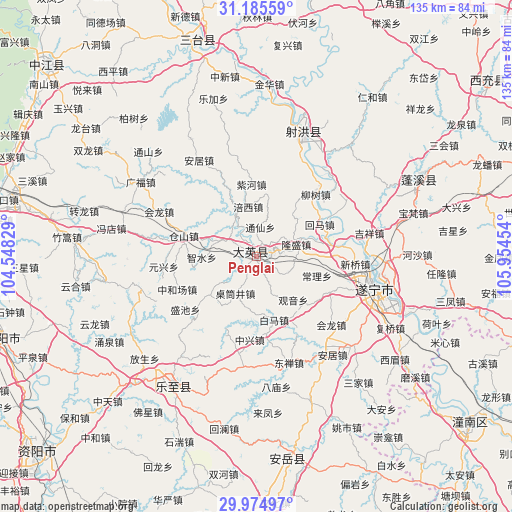
Penglai GPS coordinates[2]
30° 34' 55.812" North, 105° 15' 5.076" East
| Map corner | latitude | longitude |
|---|---|---|
| Upper-left | 31.18559°, | 104.54829° |
| Center: | 30.58217°, | 105.25141° |
| Lower-right: | 29.97497°, | 105.95454° |
| Map W x H: | 134.6×134.6 km | = 83.6×83.6mi |
| max Lat: | 53.31946° ⇑49% North |
| Penglai: | 30.58217° |
| min Lat: | ⇓51% South 18.22056° |
| min Long | Penglai | max Long |
| 75.07348° | 105.25141° | 134.28917° |
| W 11.3%⇐ | ⇒88.7% E |
Elevation
Elevation of Penglai is 316 m = 1037 ft, and this is 168.8 m = 554 ft below average elevation for this country.
| Max E: |
5622 m = 18445 ft | 35.6% |
| Avg. | 484.8 m = 1591 ft | |
| Penglai | 316 m = 1037 ft | |
Min E: |
-3 m = -10 ft | 64.4% |
See also: China elevation on elevation.city.
Geographical zone
Penglai is located in North temperate zone (between Tropic of Cancer and the Arctic Circle). Distance of this Northern Tropic circle is 794.5 km =493.7 mi to South.| Distance of | km | miles | from Penglai |
|---|---|---|---|
| North Pole | 6606.6 | 4105.1 | to North |
| Arctic Circle | 4000.8 | 2486 | to North |
| Tropic Cancer | 794.5 | 493.7 | to South |
| Equator | 3400.4 | 2112.9 | to South |


Nearby cities:
15 places around Penglai: (largest is in red/bold)
• Anju
32.5 km =20.2 mi,  142°
142°
• Baizi
70.1 km =43.6 mi, 140°
• Baolong
68.9 km =42.8 mi,  111°
111°
• Chicheng
49.2 km =30.6 mi,  63°
63°
• Chongkan
58.7 km =36.5 mi, 143°
• Guxi
65.8 km =40.9 mi,  115°
115°
• Huayan
52.1 km =32.4 mi,  133°
133°
• Mixin
54.4 km =33.8 mi, 114°
• Qunli
64.3 km =40 mi, 119°
• Shuangjiang
62.3 km =38.7 mi, 130°
• Suining
31.9 km =19.8 mi,  104°
104°
• Taihe
34.6 km =21.5 mi,  21°
21°
• Tianchi
40 km =24.9 mi,  213°
213°
• Tongchuan
59 km =36.7 mi,  344°
344°
• Yuxi
58 km =36 mi, 119°
Sources, notices
• [Note1] Compared only with cities in China existing in our database
• [Src1] Map data: © OpenStreetMap contributors (CC-BY-SA)
• [Src2] Other city data from geonames.org with taken over terms of usage.
• [Src3] Geographical zone / Annual Mean Temperature by Robert A. Rohde @ Wikipedia
