Nuojiang geodata
Nuojiang (Sichuan) is a seat of a third-order administrative division; located in China in Asia/Shanghai (GMT+8) time zone. In our database, there are 1268 cities with bigger population. Compared to other cities in China, 60.6% of cities are located further ↓South; 82.9% of cities are located further →East and 69.1% of cities have lower elevation than Nuojiang. Note1


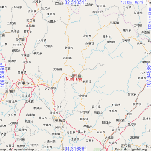
Nuojiang GPS coordinates[2]
31° 54' 56.232" North, 107° 14' 33.828" East
| Map corner | latitude | longitude |
|---|---|---|
| Upper-left | 32.51051°, | 106.53961° |
| Center: | 31.91562°, | 107.24273° |
| Lower-right: | 31.31686°, | 107.94586° |
| Map W x H: | 132.7×132.7 km | = 82.5×82.5mi |
| max Lat: | 53.31946° ⇑39.4% North |
| Nuojiang: | 31.91562° |
| min Lat: | ⇓60.6% South 18.22056° |
| min Long | Nuojiang | max Long |
| 75.07348° | 107.24273° | 134.28917° |
| W 17.1%⇐ | ⇒82.9% E |
Elevation
Elevation of Nuojiang is 395 m = 1296 ft, and this is 89.8 m = 295 ft below average elevation for this country.
| Max E: |
5622 m = 18445 ft | 30.9% |
| Avg. | 484.8 m = 1591 ft | |
| Nuojiang | 395 m = 1296 ft | |
Min E: |
-3 m = -10 ft | 69.1% |
See also: China elevation on elevation.city.
Geographical zone
Nuojiang is located in North temperate zone (between Tropic of Cancer and the Arctic Circle). Distance of this Northern Tropic circle is 942.8 km =585.8 mi to South.| Distance of | km | miles | from Nuojiang |
|---|---|---|---|
| North Pole | 6458.4 | 4013.1 | to North |
| Arctic Circle | 3852.5 | 2393.8 | to North |
| Tropic Cancer | 942.8 | 585.8 | to South |
| Equator | 3548.7 | 2205.1 | to South |


Nearby cities:
15 places around Nuojiang: (largest is in red/bold)
• Bazhong
47.3 km =29.4 mi,  263°
263°
• Bazhou
44.9 km =27.9 mi, 261°
• Changchi
61.6 km =38.3 mi,  296°
296°
• Chixi
52.3 km =32.5 mi, 300°
• Dahe
42.7 km =26.5 mi,  316°
316°
• Dongyu
59.4 km =36.9 mi, 317°
• Fujia
56.7 km =35.2 mi,  293°
293°
• Gaoqiao
43 km =26.7 mi, 297°
• Guanlu
53.2 km =33.1 mi,  331°
331°
• Heitan
57.2 km =35.5 mi,  283°
283°
• Jiangkou
41.3 km =25.7 mi,  199°
199°
• Pinggang
38.9 km =24.2 mi, 300°
• Shahe
58.3 km =36.2 mi, 303°
• Xialiang
47.9 km =29.8 mi, 291°
• Xingma
44.9 km =27.9 mi, 325°
Sources, notices
• [Note1] Compared only with cities in China existing in our database
• [Src1] Map data: © OpenStreetMap contributors (CC-BY-SA)
• [Src2] Other city data from geonames.org with taken over terms of usage.
• [Src3] Geographical zone / Annual Mean Temperature by Robert A. Rohde @ Wikipedia
