Oula geodata
Oula (Gansu) is a seat of a fourth-order administrative division; located in China in Asia/Shanghai (GMT+8) time zone. In our database, there are 1268 cities with bigger population. Compared to other cities in China, 70.5% of cities are located further ↓South; 93.1% of cities are located further →East and 97.6% of cities have lower elevation than Oula. Note1


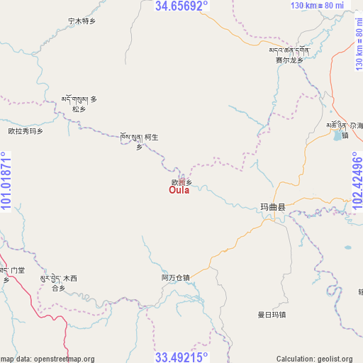
Oula GPS coordinates[2]
34° 4' 35.544" North, 101° 43' 18.588" East
| Map corner | latitude | longitude |
|---|---|---|
| Upper-left | 34.65692°, | 101.01871° |
| Center: | 34.07654°, | 101.72183° |
| Lower-right: | 33.49215°, | 102.42496° |
| Map W x H: | 129.5×129.5 km | = 80.5×80.5mi |
| max Lat: | 53.31946° ⇑29.5% North |
| Oula: | 34.07654° |
| min Lat: | ⇓70.5% South 18.22056° |
| min Long | Oula | max Long |
| 75.07348° | 101.72183° | 134.28917° |
| W 6.9%⇐ | ⇒93.1% E |
Elevation
Elevation of Oula is 3402 m = 11161 ft, and this is 2917.2 m = 9571 ft above average elevation for this country.
| Max E: |
5622 m = 18445 ft | 2.4% |
| Oula | 3402 m 11161 ft | |
| Avg. | 484.8 m = 1591 ft | |
Min E: |
-3 m = -10 ft | 97.6% |
See also: China elevation on elevation.city.
Geographical zone
Oula is located in North temperate zone (between Tropic of Cancer and the Arctic Circle). Distance of this Northern Tropic circle is 1183 km =735.1 mi to South.| Distance of | km | miles | from Oula |
|---|---|---|---|
| North Pole | 6218.1 | 3863.7 | to North |
| Arctic Circle | 3612.2 | 2244.5 | to North |
| Tropic Cancer | 1183 | 735.1 | to South |
| Equator | 3789 | 2354.4 | to South |


Nearby cities:
15 places around Oula: (largest is in red/bold)
• Awancang
34.1 km =21.2 mi,  183°
183°
• Duosong
46.4 km =28.8 mi,  307°
307°
• Kesheng
21.4 km =13.3 mi, 313°
• Maima
58.1 km =36.1 mi,  146°
146°
• Mintang
70.6 km =43.9 mi,  244°
244°
• Muxihe
56.5 km =35.1 mi,  231°
231°
• Ningmute
67.6 km =42 mi,  328°
328°
• Nyinma
33.3 km =20.7 mi,  104°
104°
• Oula Xiuma
58.4 km =36.3 mi,  288°
288°
• Qihama
81.1 km =50.4 mi,  162°
162°
• Qiujima
69.2 km =43 mi,  187°
187°
• Sai’erlong Xiang
59.3 km =36.8 mi,  39°
39°
• Tuoyema
60.7 km =37.7 mi,  343°
343°
• Youganning
74 km =46 mi,  352°
352°
• Zhiqing Songduo
76.3 km =47.4 mi,  200°
200°
Sources, notices
• [Note1] Compared only with cities in China existing in our database
• [Src1] Map data: © OpenStreetMap contributors (CC-BY-SA)
• [Src2] Other city data from geonames.org with taken over terms of usage.
• [Src3] Geographical zone / Annual Mean Temperature by Robert A. Rohde @ Wikipedia
