Muxihe geodata
Muxihe (Gansu) is a seat of a fourth-order administrative division; located in China in Asia/Shanghai (GMT+8) time zone. In our database, there are 1268 cities with bigger population. Compared to other cities in China, 69% of cities are located further ↓South; 93.6% of cities are located further →East and 97.9% of cities have lower elevation than Muxihe. Note1


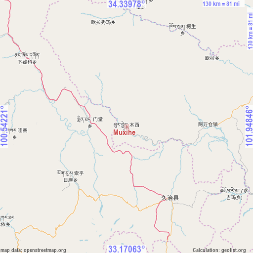
Muxihe GPS coordinates[2]
33° 45' 25.92" North, 101° 14' 43.188" East
| Map corner | latitude | longitude |
|---|---|---|
| Upper-left | 34.33978°, | 100.54221° |
| Center: | 33.7572°, | 101.24533° |
| Lower-right: | 33.17063°, | 101.94846° |
| Map W x H: | 130×130 km | = 80.8×80.8mi |
| max Lat: | 53.31946° ⇑31% North |
| Muxihe: | 33.7572° |
| min Lat: | ⇓69% South 18.22056° |
| min Long | Muxihe | max Long |
| 75.07348° | 101.24533° | 134.28917° |
| W 6.4%⇐ | ⇒93.6% E |
Elevation
Elevation of Muxihe is 3597 m = 11801 ft, and this is 3112.2 m = 10211 ft above average elevation for this country.
| Max E: |
5622 m = 18445 ft | 2.1% |
| Muxihe | 3597 m 11801 ft | |
| Avg. | 484.8 m = 1591 ft | |
Min E: |
-3 m = -10 ft | 97.9% |
See also: China elevation on elevation.city.
Geographical zone
Muxihe is located in North temperate zone (between Tropic of Cancer and the Arctic Circle). Distance of this Northern Tropic circle is 1147.5 km =713 mi to South.| Distance of | km | miles | from Muxihe |
|---|---|---|---|
| North Pole | 6253.6 | 3885.8 | to North |
| Arctic Circle | 3647.7 | 2266.6 | to North |
| Tropic Cancer | 1147.5 | 713 | to South |
| Equator | 3753.4 | 2332.3 | to South |


Nearby cities:
15 places around Muxihe: (largest is in red/bold)
• Awancang
41.8 km =26 mi,  87°
87°
• Baiyu
76.3 km =47.4 mi,  224°
224°
• Basar
59.7 km =37.1 mi,  267°
267°
• Duosong
64.1 km =39.8 mi,  6°
6°
• Kesheng
57.7 km =35.9 mi,  29°
29°
• Maima
77.3 km =48 mi,  99°
99°
• Mintang
20.2 km =12.6 mi,  283°
283°
• Nyinma
80.9 km =50.3 mi,  70°
70°
• Oula
56.5 km =35.1 mi,  51°
51°
• Oula Xiuma
55.2 km =34.3 mi,  347°
347°
• Qihama
80.3 km =49.9 mi,  121°
121°
• Qiujima
48.5 km =30.1 mi,  133°
133°
• Suohurima
38.6 km =24 mi,  228°
228°
• Xia Zanggor
61.1 km =38 mi,  304°
304°
• Zhiqing Songduo
40 km =24.9 mi,  154°
154°
Sources, notices
• [Note1] Compared only with cities in China existing in our database
• [Src1] Map data: © OpenStreetMap contributors (CC-BY-SA)
• [Src2] Other city data from geonames.org with taken over terms of usage.
• [Src3] Geographical zone / Annual Mean Temperature by Robert A. Rohde @ Wikipedia
