Kesheng geodata
Kesheng (Qinghai) is a seat of a fourth-order administrative division; located in China in Asia/Shanghai (GMT+8) time zone. In our database, there are 1268 cities with bigger population. Compared to other cities in China, 71.1% of cities are located further ↓South; 93.4% of cities are located further →East and 97.6% of cities have lower elevation than Kesheng. Note1


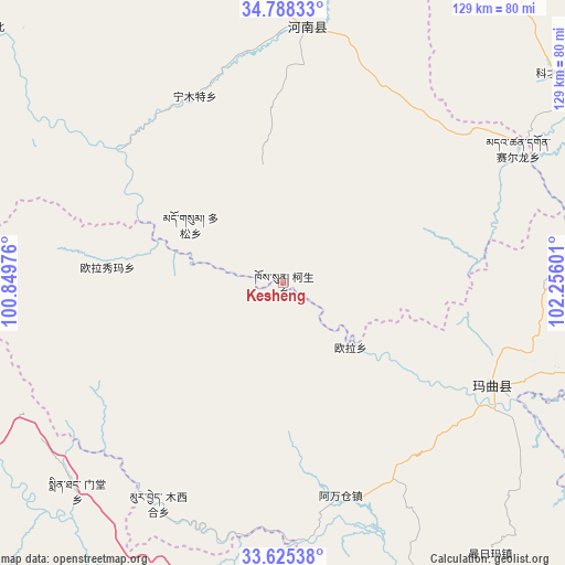
Kesheng GPS coordinates[2]
34° 12' 31.896" North, 101° 33' 10.368" East
| Map corner | latitude | longitude |
|---|---|---|
| Upper-left | 34.78833°, | 100.84976° |
| Center: | 34.20886°, | 101.55288° |
| Lower-right: | 33.62538°, | 102.25601° |
| Map W x H: | 129.3×129.3 km | = 80.3×80.3mi |
| max Lat: | 53.31946° ⇑28.9% North |
| Kesheng: | 34.20886° |
| min Lat: | ⇓71.1% South 18.22056° |
| min Long | Kesheng | max Long |
| 75.07348° | 101.55288° | 134.28917° |
| W 6.6%⇐ | ⇒93.4% E |
Elevation
Elevation of Kesheng is 3420 m = 11220 ft, and this is 2935.2 m = 9630 ft above average elevation for this country.
| Max E: |
5622 m = 18445 ft | 2.4% |
| Kesheng | 3420 m 11220 ft | |
| Avg. | 484.8 m = 1591 ft | |
Min E: |
-3 m = -10 ft | 97.6% |
See also: China elevation on elevation.city.
Geographical zone
Kesheng is located in North temperate zone (between Tropic of Cancer and the Arctic Circle). Distance of this Northern Tropic circle is 1197.7 km =744.2 mi to South.| Distance of | km | miles | from Kesheng |
|---|---|---|---|
| North Pole | 6203.4 | 3854.6 | to North |
| Arctic Circle | 3597.5 | 2235.4 | to North |
| Tropic Cancer | 1197.7 | 744.2 | to South |
| Equator | 3803.7 | 2363.5 | to South |


Nearby cities:
15 places around Kesheng: (largest is in red/bold)
• Awancang
50.5 km =31.4 mi,  164°
164°
• Duosong
25.2 km =15.7 mi,  302°
302°
• Maima
79.1 km =49.2 mi,  142°
142°
• Mintang
66 km =41 mi,  226°
226°
• Muxihe
57.7 km =35.9 mi,  209°
209°
• Ningmute
47.2 km =29.3 mi,  334°
334°
• Nyinma
53 km =32.9 mi,  115°
115°
• Oula
21.4 km =13.3 mi,  133°
133°
• Oula Xiuma
40 km =24.9 mi,  275°
275°
• Qiujima
83.6 km =51.9 mi,  175°
175°
• Sai’erlong Xiang
61.8 km =38.4 mi,  60°
60°
• Tuoyema
43.4 km =27 mi,  357°
357°
• Xia Zanggor
80.2 km =49.8 mi,  258°
258°
• Youganning
58.8 km =36.5 mi,  5°
5°
• Zhiqing Songduo
86.9 km =54 mi,  187°
187°
Sources, notices
• [Note1] Compared only with cities in China existing in our database
• [Src1] Map data: © OpenStreetMap contributors (CC-BY-SA)
• [Src2] Other city data from geonames.org with taken over terms of usage.
• [Src3] Geographical zone / Annual Mean Temperature by Robert A. Rohde @ Wikipedia
