Sanlei geodata
Sanlei (Gansu) is a seat of a third-order administrative division; located in China in Asia/Shanghai (GMT+8) time zone. In our database, there are 1268 cities with bigger population. Compared to other cities in China, 82% of cities are located further ↓South; 91.4% of cities are located further →East and 90.1% of cities have lower elevation than Sanlei. Note1


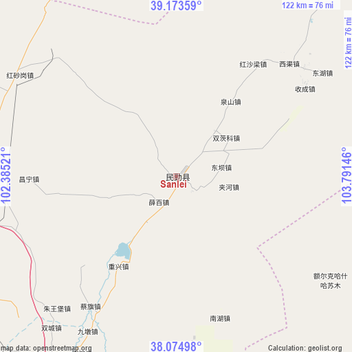
Sanlei GPS coordinates[2]
38° 37' 35.004" North, 103° 5' 17.988" East
| Map corner | latitude | longitude |
|---|---|---|
| Upper-left | 39.17359°, | 102.38521° |
| Center: | 38.62639°, | 103.08833° |
| Lower-right: | 38.07498°, | 103.79146° |
| Map W x H: | 122.2×122.2 km | = 75.9×75.9mi |
| max Lat: | 53.31946° ⇑18% North |
| Sanlei: | 38.62639° |
| min Lat: | ⇓82% South 18.22056° |
| min Long | Sanlei | max Long |
| 75.07348° | 103.08833° | 134.28917° |
| W 8.6%⇐ | ⇒91.4% E |
Elevation
Elevation of Sanlei is 1370 m = 4495 ft, and this is 885.2 m = 2904 ft above average elevation for this country.
| Max E: |
5622 m = 18445 ft | 9.9% |
| Sanlei | 1370 m 4495 ft | |
| Avg. | 484.8 m = 1591 ft | |
Min E: |
-3 m = -10 ft | 90.1% |
See also: China elevation on elevation.city.
Geographical zone
Sanlei is located in North temperate zone (between Tropic of Cancer and the Arctic Circle). Distance of this Northern Tropic circle is 1688.9 km =1049.4 mi to South.| Distance of | km | miles | from Sanlei |
|---|---|---|---|
| North Pole | 5712.2 | 3549.4 | to North |
| Arctic Circle | 3106.3 | 1930.2 | to North |
| Tropic Cancer | 1688.9 | 1049.4 | to South |
| Equator | 4294.9 | 2668.7 | to South |


Nearby cities:
15 places around Sanlei: (largest is in red/bold)
• Ailibugai
134.6 km =83.6 mi,  281°
281°
• Beitan
136.6 km =84.9 mi,  234°
234°
• Dongdajie
87.3 km =54.2 mi,  206°
206°
• Dongtan
140.6 km =87.4 mi, 232°
• Ehen Hudag
138.9 km =86.3 mi,  297°
297°
• Guangzhoulu
81.2 km =50.5 mi,  259°
259°
• Gulang
130.1 km =80.8 mi,  187°
187°
• Hongshanyao
134.6 km =83.6 mi,  254°
254°
• Huazhaizi
163.3 km =101.5 mi,  265°
265°
• Jinchang
79 km =49.1 mi, 259°
• Maying
139.9 km =86.9 mi,  239°
239°
• Wuwei
87.4 km =54.3 mi, 207°
• Xinchengzi
138.7 km =86.2 mi, 249°
• Yangxiang
118.9 km =73.9 mi, 233°
• Yongchang Chengguanzhen
101.1 km =62.8 mi, 246°
Sources, notices
• [Note1] Compared only with cities in China existing in our database
• [Src1] Map data: © OpenStreetMap contributors (CC-BY-SA)
• [Src2] Other city data from geonames.org with taken over terms of usage.
• [Src3] Geographical zone / Annual Mean Temperature by Robert A. Rohde @ Wikipedia
