Pingluo Chengguanzhen geodata
Pingluo Chengguanzhen (Ningxia Hui Autonomous Region) is a seat of a third-order administrative division; located in China in Asia/Shanghai (GMT+8) time zone. In our database, there are 1268 cities with bigger population. Compared to other cities in China, 82.5% of cities are located further ↓South; 85% of cities are located further →East and 86.8% of cities have lower elevation than Pingluo Chengguanzhen. Note1


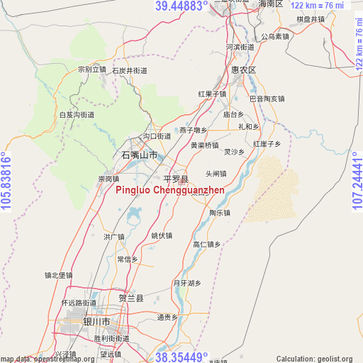
Pingluo Chengguanzhen GPS coordinates[2]
38° 54' 13.572" North, 106° 32' 28.608" East
| Map corner | latitude | longitude |
|---|---|---|
| Upper-left | 39.44883°, | 105.83816° |
| Center: | 38.90377°, | 106.54128° |
| Lower-right: | 38.35449°, | 107.24441° |
| Map W x H: | 121.7×121.7 km | = 75.6×75.6mi |
| max Lat: | 53.31946° ⇑17.5% North |
| Pingluo Chengguanzhen: | 38.90377° |
| min Lat: | ⇓82.5% South 18.22056° |
| min Long | Pingluo Chenggu | max Long |
| 75.07348° | 106.54128° | 134.28917° |
| W 15%⇐ | ⇒85% E |
Elevation
Elevation of Pingluo Chengguanzhen is 1102 m = 3615 ft, and this is 617.2 m = 2025 ft above average elevation for this country.
| Max E: |
5622 m = 18445 ft | 13.2% |
| Pingluo Chengguanzhen | 1102 m 3615 ft | |
| Avg. | 484.8 m = 1591 ft | |
Min E: |
-3 m = -10 ft | 86.8% |
See also: China elevation on elevation.city.
Geographical zone
Pingluo Chengguanzhen is located in North temperate zone (between Tropic of Cancer and the Arctic Circle). Distance of this Northern Tropic circle is 1719.8 km =1068.6 mi to South.| Distance of | km | miles | from Pingluo Chengguanzhen |
|---|---|---|---|
| North Pole | 5681.4 | 3530.3 | to North |
| Arctic Circle | 3075.5 | 1911 | to North |
| Tropic Cancer | 1719.8 | 1068.6 | to South |
| Equator | 4325.7 | 2687.9 | to South |


Nearby cities:
15 places around Pingluo Chengguanzhen: (largest is in red/bold)
• Bayan Hot
75.9 km =47.2 mi,  264°
264°
• Bayinsai
68.1 km =42.3 mi,  13°
13°
• Beijie
40.4 km =25.1 mi,  28°
28°
• Dawukou
19.9 km =12.4 mi,  320°
320°
• Dongta
93 km =57.8 mi,  190°
190°
• Lasengmiao
53.1 km =33 mi, 28°
• Qabqir
84.2 km =52.3 mi,  19°
19°
• Shitanjing
40.5 km =25.2 mi,  335°
335°
• Shizuishan
41.6 km =25.8 mi, 28°
• Wuda
67.8 km =42.1 mi, 12°
• Wuhai
90 km =55.9 mi, 15°
• Wuzhong
106.2 km =66 mi,  196°
196°
• Xigang
42.5 km =26.4 mi, 203°
• Yanghe
74.1 km =46 mi, 200°
• Yinchuan
53.7 km =33.4 mi,  205°
205°
Sources, notices
• [Note1] Compared only with cities in China existing in our database
• [Src1] Map data: © OpenStreetMap contributors (CC-BY-SA)
• [Src2] Other city data from geonames.org with taken over terms of usage.
• [Src3] Geographical zone / Annual Mean Temperature by Robert A. Rohde @ Wikipedia
