Xigang geodata
Xigang (Ningxia Hui Autonomous Region) is a seat of a third-order administrative division; located in China in Asia/Shanghai (GMT+8) time zone. In our database, there are 1268 cities with bigger population. Compared to other cities in China, 81.9% of cities are located further ↓South; 85.6% of cities are located further →East and 87% of cities have lower elevation than Xigang. Note1


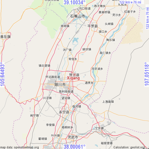
Xigang GPS coordinates[2]
38° 33' 9.288" North, 106° 20' 52.98" East
| Map corner | latitude | longitude |
|---|---|---|
| Upper-left | 39.10034°, | 105.64493° |
| Center: | 38.55258°, | 106.34805° |
| Lower-right: | 38.00061°, | 107.05118° |
| Map W x H: | 122.3×122.3 km | = 76×76mi |
| max Lat: | 53.31946° ⇑18.1% North |
| Xigang: | 38.55258° |
| min Lat: | ⇓81.9% South 18.22056° |
| min Long | Xigang | max Long |
| 75.07348° | 106.34805° | 134.28917° |
| W 14.4%⇐ | ⇒85.6% E |
Elevation
Elevation of Xigang is 1111 m = 3645 ft, and this is 626.2 m = 2054 ft above average elevation for this country.
| Max E: |
5622 m = 18445 ft | 13% |
| Xigang | 1111 m 3645 ft | |
| Avg. | 484.8 m = 1591 ft | |
Min E: |
-3 m = -10 ft | 87% |
See also: China elevation on elevation.city.
Geographical zone
Xigang is located in North temperate zone (between Tropic of Cancer and the Arctic Circle). Distance of this Northern Tropic circle is 1680.7 km =1044.3 mi to South.| Distance of | km | miles | from Xigang |
|---|---|---|---|
| North Pole | 5720.4 | 3554.5 | to North |
| Arctic Circle | 3114.5 | 1935.3 | to North |
| Tropic Cancer | 1680.7 | 1044.3 | to South |
| Equator | 4286.6 | 2663.6 | to South |


Nearby cities:
15 places around Xigang: (largest is in red/bold)
• Bayan Hot
67 km =41.6 mi,  298°
298°
• Bayinsai
110.2 km =68.5 mi,  16°
16°
• Beijie
82.8 km =51.4 mi,  25°
25°
• Dawukou
54.6 km =33.9 mi,  4°
4°
• Dongta
52.4 km =32.6 mi,  180°
180°
• Lasengmiao
95.5 km =59.3 mi, 26°
• Oljoq
106.6 km =66.2 mi,  112°
112°
• Pingluo Chengguanzhen
42.5 km =26.4 mi, 23°
• Shengli
64.6 km =40.1 mi,  191°
191°
• Shitanjing
75.8 km =47.1 mi,  359°
359°
• Shizuishan
84 km =52.2 mi, 25°
• Wuda
109.9 km =68.3 mi, 16°
• Wuzhong
64.2 km =39.9 mi, 191°
• Yanghe
31.7 km =19.7 mi,  195°
195°
• Yinchuan
11.4 km =7.1 mi,  214°
214°
Sources, notices
• [Note1] Compared only with cities in China existing in our database
• [Src1] Map data: © OpenStreetMap contributors (CC-BY-SA)
• [Src2] Other city data from geonames.org with taken over terms of usage.
• [Src3] Geographical zone / Annual Mean Temperature by Robert A. Rohde @ Wikipedia
