Lanzhou geodata
Lanzhou (Gansu) is a seat of a first-order administrative division; located in China in Asia/Shanghai (GMT+8) time zone. With population of 2,628,426 people, there are 39 cities with bigger population in this country. Compared to other cities in China, 77.3% of cities are located further ↓South; 90.5% of cities are located further →East and 91.5% of cities have lower elevation than Lanzhou. Note1


Lanzhou GPS coordinates[2]
36° 3' 25.236" North, 103° 50' 23.532" East
| Map corner | latitude | longitude |
|---|---|---|
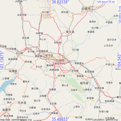
| Upper-left | 36.62338°, | 103.13675° |
| Center: | 36.05701°, | 103.83987° |
| Lower-right: | 35.48653°, | 104.543° |
| Map W x H: | 126.4×126.4 km | = 78.5×78.5mi |
| max Lat: | 53.31946° ⇑22.7% North |
| Lanzhou: | 36.05701° |
| min Lat: | ⇓77.3% South 18.22056° |
| min Long | Lanzhou | max Long |
| 75.07348° | 103.83987° | 134.28917° |
| W 9.5%⇐ | ⇒90.5% E |
Elevation
Elevation of Lanzhou is 1521 m = 4990 ft, and this is 1036.2 m = 3400 ft above average elevation for this country.
| Max E: |
5622 m = 18445 ft | 8.5% |
| Lanzhou | 1521 m 4990 ft | |
| Avg. | 484.8 m = 1591 ft | |
Min E: |
-3 m = -10 ft | 91.5% |
See also: Lanzhou elevation on elevation.city.
Geographical zone
Lanzhou is located in North temperate zone (between Tropic of Cancer and the Arctic Circle). Distance of this Northern Tropic circle is 1403.2 km =871.9 mi to South.| Distance of | km | miles | from Lanzhou |
|---|---|---|---|
| North Pole | 5997.9 | 3726.9 | to North |
| Arctic Circle | 3392 | 2107.7 | to North |
| Tropic Cancer | 1403.2 | 871.9 | to South |
| Equator | 4009.2 | 2491.2 | to South |


Nearby cities:
15 places around Lanzhou: (largest is in red/bold)
• Anning Xilu
12 km =7.5 mi,  295°
295°
• Baiyin
62 km =38.5 mi,  28°
28°
• Fucheng
77.1 km =47.9 mi,  189°
189°
• Fulilu
20.7 km =12.9 mi,  283°
283°
• Gaolan Chengguanzhen
32.3 km =20.1 mi,  17°
17°
• Guanghe Chengguanzhen
68.3 km =42.4 mi,  200°
200°
• Linxia Chengguanzhen
76.4 km =47.5 mi,  228°
228°
• Liujiaxia
48.9 km =30.4 mi,  253°
253°
• Renminlu
62.4 km =38.8 mi, 28°
• Suonan
58.9 km =36.6 mi,  222°
222°
• Taoyang
72.9 km =45.3 mi,  179°
179°
• Xiaoling
78.1 km =48.5 mi,  256°
256°
• Xihu
5.8 km =3.6 mi, 281°
• Yuzhong Chengguanzhen
34.2 km =21.3 mi,  134°
134°
• Zhangyelu
1.5 km =0.9 mi,  272°
272°
Sources, notices
• [Note1] Compared only with cities in China existing in our database
• [Src1] Map data: © OpenStreetMap contributors (CC-BY-SA)
• [Src2] Other city data from geonames.org with taken over terms of usage.
• [Src3] Geographical zone / Annual Mean Temperature by Robert A. Rohde @ Wikipedia
