Zhangyelu geodata
Zhangyelu (Gansu) is a seat of a third-order administrative division; located in China in Asia/Shanghai (GMT+8) time zone. In our database, there are 1268 cities with bigger population. Compared to other cities in China, 77.3% of cities are located further ↓South; 90.6% of cities are located further →East and 91.6% of cities have lower elevation than Zhangyelu. Note1


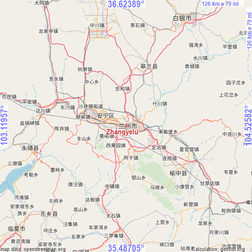
Zhangyelu GPS coordinates[2]
36° 3' 27.072" North, 103° 49' 21.684" East
| Map corner | latitude | longitude |
|---|---|---|
| Upper-left | 36.62389°, | 103.11957° |
| Center: | 36.05752°, | 103.82269° |
| Lower-right: | 35.48705°, | 104.52582° |
| Map W x H: | 126.4×126.4 km | = 78.5×78.5mi |
| max Lat: | 53.31946° ⇑22.7% North |
| Zhangyelu: | 36.05752° |
| min Lat: | ⇓77.3% South 18.22056° |
| min Long | Zhangyelu | max Long |
| 75.07348° | 103.82269° | 134.28917° |
| W 9.4%⇐ | ⇒90.6% E |
Elevation
Elevation of Zhangyelu is 1527 m = 5010 ft, and this is 1042.2 m = 3419 ft above average elevation for this country.
| Max E: |
5622 m = 18445 ft | 8.4% |
| Zhangyelu | 1527 m 5010 ft | |
| Avg. | 484.8 m = 1591 ft | |
Min E: |
-3 m = -10 ft | 91.6% |
See also: China elevation on elevation.city.
Geographical zone
Zhangyelu is located in North temperate zone (between Tropic of Cancer and the Arctic Circle). Distance of this Northern Tropic circle is 1403.3 km =872 mi to South.| Distance of | km | miles | from Zhangyelu |
|---|---|---|---|
| North Pole | 5997.8 | 3726.9 | to North |
| Arctic Circle | 3392 | 2107.7 | to North |
| Tropic Cancer | 1403.3 | 872 | to South |
| Equator | 4009.2 | 2491.2 | to South |


Nearby cities:
15 places around Zhangyelu: (largest is in red/bold)
• Anning Xilu
10.6 km =6.6 mi,  298°
298°
• Baiyin
62.7 km =39 mi,  29°
29°
• Fucheng
76.9 km =47.8 mi,  187°
187°
• Fulilu
19.2 km =11.9 mi,  284°
284°
• Gaolan Chengguanzhen
32.7 km =20.3 mi,  19°
19°
• Guanghe Chengguanzhen
67.8 km =42.1 mi,  199°
199°
• Lanzhou
1.5 km =0.9 mi,  92°
92°
• Linxia Chengguanzhen
75.3 km =46.8 mi,  227°
227°
• Liujiaxia
47.4 km =29.5 mi,  253°
253°
• Renminlu
63.1 km =39.2 mi, 29°
• Suonan
57.9 km =36 mi,  221°
221°
• Taoyang
73 km =45.4 mi,  177°
177°
• Xiaoling
76.6 km =47.6 mi,  256°
256°
• Xihu
4.3 km =2.7 mi, 284°
• Yuzhong Chengguanzhen
35.4 km =22 mi,  132°
132°
Sources, notices
• [Note1] Compared only with cities in China existing in our database
• [Src1] Map data: © OpenStreetMap contributors (CC-BY-SA)
• [Src2] Other city data from geonames.org with taken over terms of usage.
• [Src3] Geographical zone / Annual Mean Temperature by Robert A. Rohde @ Wikipedia
