Huishi geodata
Huishi (Gansu) is a seat of a third-order administrative division; located in China in Asia/Shanghai (GMT+8) time zone. In our database, there are 1268 cities with bigger population. Compared to other cities in China, 76.5% of cities are located further ↓South; 89% of cities are located further →East and 93.2% of cities have lower elevation than Huishi. Note1


Huishi GPS coordinates[2]
35° 41' 31.056" North, 105° 2' 54.888" East
| Map corner | latitude | longitude |
|---|---|---|
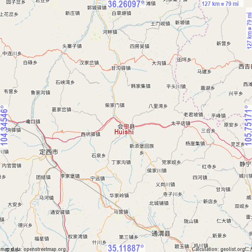
| Upper-left | 36.26097°, | 104.34546° |
| Center: | 35.69196°, | 105.04858° |
| Lower-right: | 35.11887°, | 105.75171° |
| Map W x H: | 127×127 km | = 78.9×78.9mi |
| max Lat: | 53.31946° ⇑23.5% North |
| Huishi: | 35.69196° |
| min Lat: | ⇓76.5% South 18.22056° |
| min Long | Huishi | max Long |
| 75.07348° | 105.04858° | 134.28917° |
| W 11%⇐ | ⇒89% E |
Elevation
Elevation of Huishi is 1730 m = 5676 ft, and this is 1245.2 m = 4085 ft above average elevation for this country.
| Max E: |
5622 m = 18445 ft | 6.8% |
| Huishi | 1730 m 5676 ft | |
| Avg. | 484.8 m = 1591 ft | |
Min E: |
-3 m = -10 ft | 93.2% |
See also: China elevation on elevation.city.
Geographical zone
Huishi is located in North temperate zone (between Tropic of Cancer and the Arctic Circle). Distance of this Northern Tropic circle is 1362.7 km =846.7 mi to South.| Distance of | km | miles | from Huishi |
|---|---|---|---|
| North Pole | 6038.5 | 3752.1 | to North |
| Arctic Circle | 3432.6 | 2132.9 | to North |
| Tropic Cancer | 1362.7 | 846.7 | to South |
| Equator | 3968.6 | 2466 | to South |


Nearby cities:
15 places around Huishi: (largest is in red/bold)
• Dagou
36.1 km =22.4 mi,  27°
27°
• Dangjiaxian
29.1 km =18.1 mi,  128°
128°
• Dingxi
40.7 km =25.3 mi,  250°
250°
• Gangouyi
29.5 km =18.3 mi,  354°
354°
• Hanjiaji
21.8 km =13.5 mi,  19°
19°
• Houjiachuan
27 km =16.8 mi,  144°
144°
• Huajialing
35 km =21.7 mi,  185°
185°
• Jieshipu
45.1 km =28 mi,  101°
101°
• Laojunpo
34.2 km =21.3 mi,  79°
79°
• Maying
43.1 km =26.8 mi,  183°
183°
• Pingfeng
46.7 km =29 mi, 83°
• Qingjiangyi
35.3 km =21.9 mi,  92°
92°
• Yuan’an
52.9 km =32.9 mi, 88°
• Zhongchuan
21.7 km =13.5 mi,  172°
172°
• Zhonghualu
42 km =26.1 mi,  256°
256°
Sources, notices
• [Note1] Compared only with cities in China existing in our database
• [Src1] Map data: © OpenStreetMap contributors (CC-BY-SA)
• [Src2] Other city data from geonames.org with taken over terms of usage.
• [Src3] Geographical zone / Annual Mean Temperature by Robert A. Rohde @ Wikipedia
