Gangouyi geodata
Gangouyi (Gansu) is a seat of a fourth-order administrative division; located in China in Asia/Shanghai (GMT+8) time zone. In our database, there are 1268 cities with bigger population. Compared to other cities in China, 77.1% of cities are located further ↓South; 89% of cities are located further →East and 92.5% of cities have lower elevation than Gangouyi. Note1


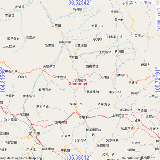
Gangouyi GPS coordinates[2]
35° 57' 22.752" North, 105° 1' 7.608" East
| Map corner | latitude | longitude |
|---|---|---|
| Upper-left | 36.52342°, | 104.31566° |
| Center: | 35.95632°, | 105.01878° |
| Lower-right: | 35.38512°, | 105.72191° |
| Map W x H: | 126.6×126.6 km | = 78.7×78.7mi |
| max Lat: | 53.31946° ⇑22.9% North |
| Gangouyi: | 35.95632° |
| min Lat: | ⇓77.1% South 18.22056° |
| min Long | Gangouyi | max Long |
| 75.07348° | 105.01878° | 134.28917° |
| W 11%⇐ | ⇒89% E |
Elevation
Elevation of Gangouyi is 1634 m = 5361 ft, and this is 1149.2 m = 3770 ft above average elevation for this country.
| Max E: |
5622 m = 18445 ft | 7.5% |
| Gangouyi | 1634 m 5361 ft | |
| Avg. | 484.8 m = 1591 ft | |
Min E: |
-3 m = -10 ft | 92.5% |
See also: China elevation on elevation.city.
Geographical zone
Gangouyi is located in North temperate zone (between Tropic of Cancer and the Arctic Circle). Distance of this Northern Tropic circle is 1392 km =864.9 mi to South.| Distance of | km | miles | from Gangouyi |
|---|---|---|---|
| North Pole | 6009.1 | 3733.9 | to North |
| Arctic Circle | 3403.2 | 2114.6 | to North |
| Tropic Cancer | 1392 | 864.9 | to South |
| Equator | 3998 | 2484.2 | to South |


Nearby cities:
15 places around Gangouyi: (largest is in red/bold)
• Dagou
19.4 km =12.1 mi,  82°
82°
• Dangjiaxian
53.8 km =33.4 mi,  151°
151°
• Dingxi
55.8 km =34.7 mi,  219°
219°
• Hanjiaji
13.3 km =8.3 mi,  131°
131°
• Houjiachuan
54.6 km =33.9 mi,  160°
160°
• Huajialing
64.2 km =39.9 mi,  180°
180°
• Huishi
29.5 km =18.3 mi,  174°
174°
• Jieshipu
60.6 km =37.7 mi, 129°
• Laojunpo
43.1 km =26.8 mi,  122°
122°
• Pingfeng
54.5 km =33.9 mi, 115°
• Qingjiangyi
49 km =30.4 mi, 129°
• Xingping
59.2 km =36.8 mi,  102°
102°
• Yuan’an
62.3 km =38.7 mi, 117°
• Zhongchuan
51.2 km =31.8 mi, 174°
• Zhonghualu
54.5 km =33.9 mi, 224°
Sources, notices
• [Note1] Compared only with cities in China existing in our database
• [Src1] Map data: © OpenStreetMap contributors (CC-BY-SA)
• [Src2] Other city data from geonames.org with taken over terms of usage.
• [Src3] Geographical zone / Annual Mean Temperature by Robert A. Rohde @ Wikipedia
