Zhonghualu geodata
Zhonghualu (Gansu) is a seat of a third-order administrative division; located in China in Asia/Shanghai (GMT+8) time zone. In our database, there are 1268 cities with bigger population. Compared to other cities in China, 76.3% of cities are located further ↓South; 89.6% of cities are located further →East and 94.1% of cities have lower elevation than Zhonghualu. Note1


Zhonghualu GPS coordinates[2]
35° 36' 18.9" North, 104° 35' 48.048" East
| Map corner | latitude | longitude |
|---|---|---|
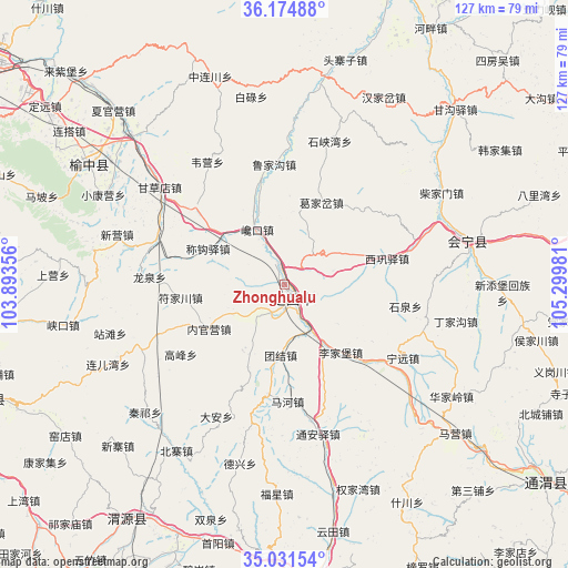
| Upper-left | 36.17488°, | 103.89356° |
| Center: | 35.60525°, | 104.59668° |
| Lower-right: | 35.03154°, | 105.29981° |
| Map W x H: | 127.1×127.1 km | = 79×79mi |
| max Lat: | 53.31946° ⇑23.7% North |
| Zhonghualu: | 35.60525° |
| min Lat: | ⇓76.3% South 18.22056° |
| min Long | Zhonghualu | max Long |
| 75.07348° | 104.59668° | 134.28917° |
| W 10.4%⇐ | ⇒89.6% E |
Elevation
Elevation of Zhonghualu is 1889 m = 6198 ft, and this is 1404.2 m = 4607 ft above average elevation for this country.
| Max E: |
5622 m = 18445 ft | 5.9% |
| Zhonghualu | 1889 m 6198 ft | |
| Avg. | 484.8 m = 1591 ft | |
Min E: |
-3 m = -10 ft | 94.1% |
See also: China elevation on elevation.city.
Geographical zone
Zhonghualu is located in North temperate zone (between Tropic of Cancer and the Arctic Circle). Distance of this Northern Tropic circle is 1353 km =840.7 mi to South.| Distance of | km | miles | from Zhonghualu |
|---|---|---|---|
| North Pole | 6048.1 | 3758.1 | to North |
| Arctic Circle | 3442.2 | 2138.9 | to North |
| Tropic Cancer | 1353 | 840.7 | to South |
| Equator | 3958.9 | 2459.9 | to South |


Nearby cities:
15 places around Zhonghualu: (largest is in red/bold)
• Caizi Zhen
69.5 km =43.2 mi,  189°
189°
• Dagou
70.9 km =44.1 mi,  54°
54°
• Dangjiaxian
64.3 km =40 mi,  97°
97°
• Dingxi
4.5 km =2.8 mi,  148°
148°
• Gangouyi
54.5 km =33.9 mi,  44°
44°
• Gongchang Zhen
67.5 km =41.9 mi,  176°
176°
• Hanjiaji
56.8 km =35.3 mi,  57°
57°
• Houjiachuan
57.8 km =35.9 mi, 102°
• Huajialing
45 km =28 mi,  123°
123°
• Huishi
42 km =26.1 mi,  76°
76°
• Maying
50.9 km =31.6 mi,  130°
130°
• Qingyuan
62.2 km =38.6 mi,  213°
213°
• Taoyang
71 km =44.1 mi,  251°
251°
• Yuzhong Chengguanzhen
51.1 km =31.8 mi,  301°
301°
• Zhongchuan
45.1 km =28 mi,  105°
105°
Sources, notices
• [Note1] Compared only with cities in China existing in our database
• [Src1] Map data: © OpenStreetMap contributors (CC-BY-SA)
• [Src2] Other city data from geonames.org with taken over terms of usage.
• [Src3] Geographical zone / Annual Mean Temperature by Robert A. Rohde @ Wikipedia
