Si’en geodata
Si’en (Guangxi) is a seat of a third-order administrative division; located in China in Asia/Shanghai (GMT+8) time zone. In our database, there are 1268 cities with bigger population. Compared to other cities in China, 87% of cities are located further ↑North; 79.6% of cities are located further →East and 57.7% of cities have lower elevation than Si’en. Note1


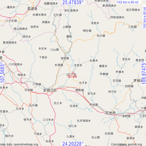
Si’en GPS coordinates[2]
24° 50' 31.128" North, 108° 16' 17.832" East
| Map corner | latitude | longitude |
|---|---|---|
| Upper-left | 25.47839°, | 107.5685° |
| Center: | 24.84198°, | 108.27162° |
| Lower-right: | 24.20228°, | 108.97475° |
| Map W x H: | 141.9×141.9 km | = 88.2×88.2mi |
| max Lat: | 53.31946° ⇑87% North |
| Si’en: | 24.84198° |
| min Lat: | ⇓13% South 18.22056° |
| min Long | Si’en | max Long |
| 75.07348° | 108.27162° | 134.28917° |
| W 20.4%⇐ | ⇒79.6% E |
Elevation
Elevation of Si’en is 233 m = 764 ft, and this is 251.8 m = 826 ft below average elevation for this country.
| Max E: |
5622 m = 18445 ft | 42.3% |
| Avg. | 484.8 m = 1591 ft | |
| Si’en | 233 m = 764 ft | |
Min E: |
-3 m = -10 ft | 57.7% |
See also: China elevation on elevation.city.
Geographical zone
Si’en is located in North temperate zone (between Tropic of Cancer and the Arctic Circle). Distance of this Northern Tropic circle is 156.3 km =97.1 mi to South.| Distance of | km | miles | from Si’en |
|---|---|---|---|
| North Pole | 7244.9 | 4501.8 | to North |
| Arctic Circle | 4639 | 2882.5 | to North |
| Tropic Cancer | 156.3 | 97.1 | to South |
| Equator | 2762.2 | 1716.4 | to South |


Nearby cities:
15 places around Si’en: (largest is in red/bold)
• Anyang
102 km =63.4 mi,  189°
189°
• Chuanshan
31.4 km =19.5 mi,  322°
322°
• Dabu
99.2 km =61.6 mi,  101°
101°
• Dingdan
112.7 km =70 mi,  359°
359°
• Donglan
95.5 km =59.3 mi,  250°
250°
• Dongmen
63.7 km =39.6 mi, 95°
• Gaowu
102.6 km =63.8 mi,  38°
38°
• Liupai
112.9 km =70.2 mi,  281°
281°
• Maolan
64 km =39.8 mi,  342°
342°
• Nandan Chengguanzhen
74.4 km =46.2 mi, 284°
• Rongshui
101.7 km =63.2 mi,  75°
75°
• Tingdong
114.5 km =71.1 mi,  17°
17°
• Xiajiang
110 km =68.4 mi, 22°
• Xincheng Chengguanzhen
92.5 km =57.5 mi,  155°
155°
• Yaolu
71.1 km =44.2 mi, 342°
Sources, notices
• [Note1] Compared only with cities in China existing in our database
• [Src1] Map data: © OpenStreetMap contributors (CC-BY-SA)
• [Src2] Other city data from geonames.org with taken over terms of usage.
• [Src3] Geographical zone / Annual Mean Temperature by Robert A. Rohde @ Wikipedia
