Dongkou geodata
Dongkou (Hunan) is a seat of a third-order administrative division; located in China in Asia/Shanghai (GMT+8) time zone. In our database, there are 1268 cities with bigger population. Compared to other cities in China, 78.4% of cities are located further ↑North; 69% of cities are located further →East and 69.6% of cities have lower elevation than Dongkou. Note1


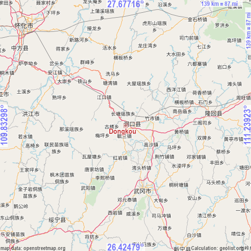
Dongkou GPS coordinates[2]
27° 3' 9.792" North, 110° 32' 9.96" East
| Map corner | latitude | longitude |
|---|---|---|
| Upper-left | 27.67716°, | 109.83298° |
| Center: | 27.05272°, | 110.5361° |
| Lower-right: | 26.42479°, | 111.23923° |
| Map W x H: | 139.3×139.3 km | = 86.6×86.6mi |
| max Lat: | 53.31946° ⇑78.4% North |
| Dongkou: | 27.05272° |
| min Lat: | ⇓21.6% South 18.22056° |
| min Long | Dongkou | max Long |
| 75.07348° | 110.5361° | 134.28917° |
| W 31%⇐ | ⇒69% E |
Elevation
Elevation of Dongkou is 403 m = 1322 ft, and this is 81.8 m = 268 ft below average elevation for this country.
| Max E: |
5622 m = 18445 ft | 30.4% |
| Avg. | 484.8 m = 1591 ft | |
| Dongkou | 403 m = 1322 ft | |
Min E: |
-3 m = -10 ft | 69.6% |
See also: China elevation on elevation.city.
Geographical zone
Dongkou is located in North temperate zone (between Tropic of Cancer and the Arctic Circle). Distance of this Northern Tropic circle is 402.1 km =249.9 mi to South.| Distance of | km | miles | from Dongkou |
|---|---|---|---|
| North Pole | 6999.1 | 4349 | to North |
| Arctic Circle | 4393.2 | 2729.8 | to North |
| Tropic Cancer | 402.1 | 249.9 | to South |
| Equator | 3008 | 1869.1 | to South |


Nearby cities:
15 places around Dongkou: (largest is in red/bold)
• Daping
39.4 km =24.5 mi,  324°
324°
• Hengbanqiao
35.2 km =21.9 mi,  67°
67°
• Huangqiao
30.3 km =18.8 mi,  96°
96°
• Huangtukuang
19.9 km =12.4 mi,  219°
219°
• Huayuan
15.5 km =9.6 mi,  180°
180°
• Jiangkou
20.2 km =12.6 mi, 319°
• Lixiqiao
31 km =19.3 mi,  202°
202°
• Ma’an
20.1 km =12.5 mi,  114°
114°
• Nanyuemiao
32.3 km =20.1 mi,  75°
75°
• Shanmen
24.6 km =15.3 mi,  38°
38°
• Shijiang
25.7 km =16 mi, 82°
• Tangjiafang
29.1 km =18.1 mi, 215°
• Wantouqiao
24.9 km =15.5 mi,  160°
160°
• Xiyangjiang
32.8 km =20.4 mi,  62°
62°
• Zhushi
14.5 km =9 mi, 74°
Sources, notices
• [Note1] Compared only with cities in China existing in our database
• [Src1] Map data: © OpenStreetMap contributors (CC-BY-SA)
• [Src2] Other city data from geonames.org with taken over terms of usage.
• [Src3] Geographical zone / Annual Mean Temperature by Robert A. Rohde @ Wikipedia
