Daming geodata
Daming (Hebei) is a seat of a third-order administrative division; located in China in Asia/Shanghai (GMT+8) time zone. In our database, there are 1268 cities with bigger population. Compared to other cities in China, 77.8% of cities are located further ↓South; 55.1% of cities are located further ←West and 71% of cities have higher elevation than Daming. Note1


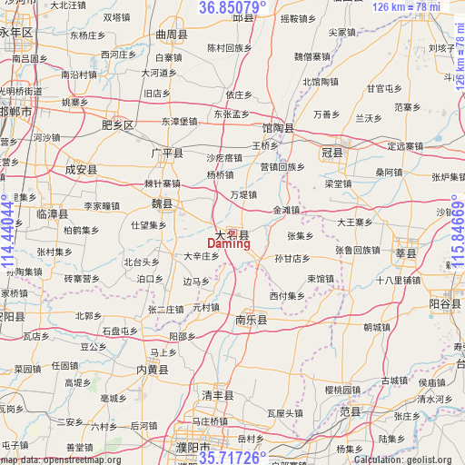
Daming GPS coordinates[2]
36° 17' 9.888" North, 115° 8' 36.816" East
| Map corner | latitude | longitude |
|---|---|---|
| Upper-left | 36.85079°, | 114.44044° |
| Center: | 36.28608°, | 115.14356° |
| Lower-right: | 35.71726°, | 115.84669° |
| Map W x H: | 126×126 km | = 78.3×78.3mi |
| max Lat: | 53.31946° ⇑22.2% North |
| Daming: | 36.28608° |
| min Lat: | ⇓77.8% South 18.22056° |
| min Long | Daming | max Long |
| 75.07348° | 115.14356° | 134.28917° |
| W 55.1%⇐ | ⇒44.9% E |
Elevation
Elevation of Daming is 48 m = 157 ft, and this is 436.8 m = 1433 ft below average elevation for this country.
| Max E: |
5622 m = 18445 ft | 71% |
| Avg. | 484.8 m = 1591 ft | |
| Daming | 48 m = 157 ft | |
Min E: |
-3 m = -10 ft | 29% |
See also: China elevation on elevation.city.
Geographical zone
Daming is located in North temperate zone (between Tropic of Cancer and the Arctic Circle). Distance of this Northern Tropic circle is 1428.7 km =887.8 mi to South.| Distance of | km | miles | from Daming |
|---|---|---|---|
| North Pole | 5972.4 | 3711.1 | to North |
| Arctic Circle | 3366.5 | 2091.8 | to North |
| Tropic Cancer | 1428.7 | 887.8 | to South |
| Equator | 4034.6 | 2507 | to South |


Nearby cities:
15 places around Daming: (largest is in red/bold)
• Chensan
50.1 km =31.1 mi,  359°
359°
• Dongliang’erzhuang
50.1 km =31.1 mi,  11°
11°
• Dongluqiao
47.4 km =29.5 mi,  21°
21°
• Fan Xian Chengguanzhen
57.4 km =35.7 mi,  146°
146°
• Guancheng
33.9 km =21.1 mi,  50°
50°
• Guantao
31 km =19.3 mi, 23°
• Nanle Chengguanzhen
23.9 km =14.9 mi,  167°
167°
• Neihuang Chengguanzhen
43.1 km =26.8 mi,  210°
210°
• Puyang
59.2 km =36.8 mi,  191°
191°
• Qingfeng Chengguanzhen
42.7 km =26.5 mi,  184°
184°
• Xinmatou
59.2 km =36.8 mi,  2°
2°
• Xiying
22.6 km =14 mi,  36°
36°
• Yanggu
59.9 km =37.2 mi,  108°
108°
• Yanta
47.2 km =29.3 mi,  96°
96°
• Zhongyuanlu
58 km =36 mi, 187°
Sources, notices
• [Note1] Compared only with cities in China existing in our database
• [Src1] Map data: © OpenStreetMap contributors (CC-BY-SA)
• [Src2] Other city data from geonames.org with taken over terms of usage.
• [Src3] Geographical zone / Annual Mean Temperature by Robert A. Rohde @ Wikipedia
