Guantao geodata
Guantao (Hebei) is a seat of a third-order administrative division; located in China in Asia/Shanghai (GMT+8) time zone. In our database, there are 1268 cities with bigger population. Compared to other cities in China, 78.3% of cities are located further ↓South; 55.7% of cities are located further ←West and 72.7% of cities have higher elevation than Guantao. Note1


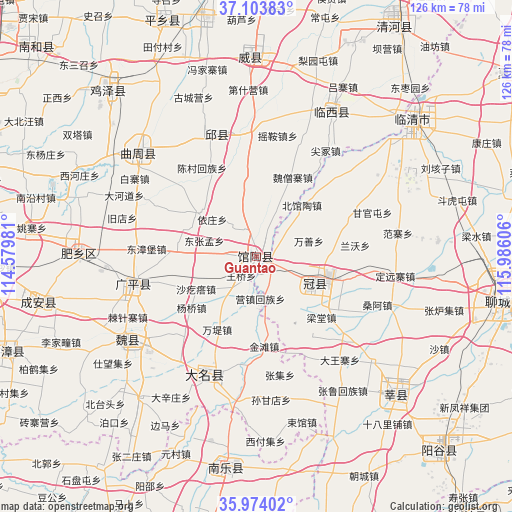
Guantao GPS coordinates[2]
36° 32' 27.564" North, 115° 16' 58.548" East
| Map corner | latitude | longitude |
|---|---|---|
| Upper-left | 37.10383°, | 114.57981° |
| Center: | 36.54099°, | 115.28293° |
| Lower-right: | 35.97402°, | 115.98606° |
| Map W x H: | 125.6×125.6 km | = 78×78mi |
| max Lat: | 53.31946° ⇑21.7% North |
| Guantao: | 36.54099° |
| min Lat: | ⇓78.3% South 18.22056° |
| min Long | Guantao | max Long |
| 75.07348° | 115.28293° | 134.28917° |
| W 55.7%⇐ | ⇒44.3% E |
Elevation
Elevation of Guantao is 43 m = 141 ft, and this is 441.8 m = 1449 ft below average elevation for this country.
| Max E: |
5622 m = 18445 ft | 72.7% |
| Avg. | 484.8 m = 1591 ft | |
| Guantao | 43 m = 141 ft | |
Min E: |
-3 m = -10 ft | 27.3% |
See also: China elevation on elevation.city.
Geographical zone
Guantao is located in North temperate zone (between Tropic of Cancer and the Arctic Circle). Distance of this Northern Tropic circle is 1457.1 km =905.4 mi to South.| Distance of | km | miles | from Guantao |
|---|---|---|---|
| North Pole | 5944.1 | 3693.5 | to North |
| Arctic Circle | 3338.2 | 2074.3 | to North |
| Tropic Cancer | 1457.1 | 905.4 | to South |
| Equator | 4063 | 2524.6 | to South |


Nearby cities:
15 places around Guantao: (largest is in red/bold)
• Chensan
25.5 km =15.8 mi,  328°
328°
• Daming
31 km =19.3 mi,  203°
203°
• Dongliang’erzhuang
20.8 km =12.9 mi,  353°
353°
• Dongluqiao
16.5 km =10.3 mi,  18°
18°
• Gaobeijie
50.1 km =31.1 mi,  45°
45°
• Guancheng
15.2 km =9.4 mi,  116°
116°
• Gulou
61.8 km =38.4 mi,  100°
100°
• Liaocheng
62.8 km =39 mi, 98°
• Mingzhou
48.4 km =30.1 mi,  357°
357°
• Nanle Chengguanzhen
52.2 km =32.4 mi,  188°
188°
• Qiangezhai
47.8 km =29.7 mi,  10°
10°
• Qingnian
50.7 km =31.5 mi, 48°
• Xinmatou
32.4 km =20.1 mi,  341°
341°
• Xiying
10.3 km =6.4 mi,  174°
174°
• Yanta
47.9 km =29.8 mi,  134°
134°
Sources, notices
• [Note1] Compared only with cities in China existing in our database
• [Src1] Map data: © OpenStreetMap contributors (CC-BY-SA)
• [Src2] Other city data from geonames.org with taken over terms of usage.
• [Src3] Geographical zone / Annual Mean Temperature by Robert A. Rohde @ Wikipedia
