Xinmatou geodata
Xinmatou (Hebei) is a seat of a third-order administrative division; located in China in Asia/Shanghai (GMT+8) time zone. In our database, there are 1268 cities with bigger population. Compared to other cities in China, 78.8% of cities are located further ↓South; 55.2% of cities are located further ←West and 73.3% of cities have higher elevation than Xinmatou. Note1


Xinmatou GPS coordinates[2]
36° 49' 4.872" North, 115° 10' 13.692" East
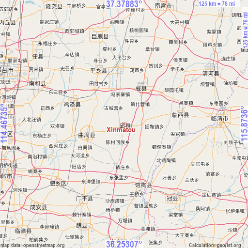
| Map corner | latitude | longitude |
|---|---|---|
| Upper-left | 37.37883°, | 114.46735° |
| Center: | 36.81802°, | 115.17047° |
| Lower-right: | 36.25307°, | 115.8736° |
| Map W x H: | 125.2×125.2 km | = 77.8×77.8mi |
| max Lat: | 53.31946° ⇑21.2% North |
| Xinmatou: | 36.81802° |
| min Lat: | ⇓78.8% South 18.22056° |
| min Long | Xinmatou | max Long |
| 75.07348° | 115.17047° | 134.28917° |
| W 55.2%⇐ | ⇒44.8% E |
Elevation
Elevation of Xinmatou is 41 m = 135 ft, and this is 443.8 m = 1456 ft below average elevation for this country.
| Max E: |
5622 m = 18445 ft | 73.3% |
| Avg. | 484.8 m = 1591 ft | |
| Xinmatou | 41 m = 135 ft | |
Min E: |
-3 m = -10 ft | 26.7% |
See also: China elevation on elevation.city.
Geographical zone
Xinmatou is located in North temperate zone (between Tropic of Cancer and the Arctic Circle). Distance of this Northern Tropic circle is 1487.9 km =924.5 mi to South.| Distance of | km | miles | from Xinmatou |
|---|---|---|---|
| North Pole | 5913.3 | 3674.4 | to North |
| Arctic Circle | 3307.4 | 2055.1 | to North |
| Tropic Cancer | 1487.9 | 924.5 | to South |
| Equator | 4093.8 | 2543.8 | to South |


Nearby cities:
15 places around Xinmatou: (largest is in red/bold)
• Chensan
9.6 km =6 mi,  199°
199°
• Daming
59.2 km =36.8 mi,  182°
182°
• Dongliang’erzhuang
12.6 km =7.8 mi,  143°
143°
• Dongluqiao
21.5 km =13.4 mi, 135°
• Gaobeijie
45.8 km =28.5 mi,  84°
84°
• Guancheng
44.4 km =27.6 mi,  147°
147°
• Guantao
32.4 km =20.1 mi,  161°
161°
• Liuzhuang
57.5 km =35.7 mi,  68°
68°
• Mingzhou
19.2 km =11.9 mi,  23°
23°
• Nangong
62.7 km =39 mi, 16°
• Qiangezhai
24.6 km =15.3 mi,  48°
48°
• Qingnian
48.2 km =30 mi,  87°
87°
• Shahecheng
60.6 km =37.7 mi,  282°
282°
• Xiying
42.5 km =26.4 mi, 164°
• Youfang
57.4 km =35.7 mi, 68°
Sources, notices
• [Note1] Compared only with cities in China existing in our database
• [Src1] Map data: © OpenStreetMap contributors (CC-BY-SA)
• [Src2] Other city data from geonames.org with taken over terms of usage.
• [Src3] Geographical zone / Annual Mean Temperature by Robert A. Rohde @ Wikipedia
