Kangding geodata
Kangding (Sichuan) is a seat of a second-order administrative division; located in China in Asia/Shanghai (GMT+8) time zone. With population of 100,000 people, there are 425 cities with bigger population in this country. Compared to other cities in China, 54% of cities are located further ↑North; 92.9% of cities are located further →East and 96.5% of cities have lower elevation than Kangding. Note1


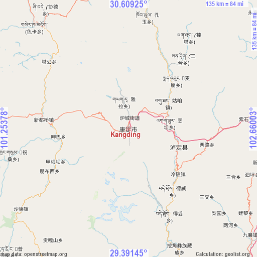
Kangding GPS coordinates[2]
30° 0' 7.992" North, 101° 57' 24.84" East
| Map corner | latitude | longitude |
|---|---|---|
| Upper-left | 30.60925°, | 101.25378° |
| Center: | 30.00222°, | 101.9569° |
| Lower-right: | 29.39145°, | 102.66003° |
| Map W x H: | 135.4×135.4 km | = 84.1×84.1mi |
| max Lat: | 53.31946° ⇑54% North |
| Kangding: | 30.00222° |
| min Lat: | ⇓46% South 18.22056° |
| min Long | Kangding | max Long |
| 75.07348° | 101.9569° | 134.28917° |
| W 7.1%⇐ | ⇒92.9% E |
Elevation
Elevation of Kangding is 2826 m = 9272 ft, and this is 2341.2 m = 7681 ft above average elevation for this country.
| Max E: |
5622 m = 18445 ft | 3.5% |
| Kangding | 2826 m 9272 ft | |
| Avg. | 484.8 m = 1591 ft | |
Min E: |
-3 m = -10 ft | 96.5% |
See also: Kangding elevation on elevation.city.
Geographical zone
Kangding is located in North temperate zone (between Tropic of Cancer and the Arctic Circle). Distance of this Northern Tropic circle is 730 km =453.6 mi to South.| Distance of | km | miles | from Kangding |
|---|---|---|---|
| North Pole | 6671.1 | 4145.2 | to North |
| Arctic Circle | 4065.2 | 2526 | to North |
| Tropic Cancer | 730 | 453.6 | to South |
| Equator | 3335.9 | 2072.8 | to South |


Nearby cities:
15 places around Kangding: (largest is in red/bold)
• Hepingyizu
137.4 km =85.4 mi,  127°
127°
• Linqiong
151.7 km =94.3 mi,  72°
72°
• Luqiao
27.6 km =17.1 mi,  106°
106°
• Meixing
117.4 km =72.9 mi,  19°
19°
• Muping
91.8 km =57 mi,  63°
63°
• Nan’an
150.1 km =93.3 mi,  99°
99°
• Shaping
152.9 km =95 mi,  124°
124°
• Shirong
98.8 km =61.4 mi,  137°
137°
• Suishan
153.9 km =95.6 mi, 106°
• Xianshui
135.7 km =84.3 mi,  324°
324°
• Xia’er
118.8 km =73.8 mi,  201°
201°
• Xinmian
93.8 km =58.3 mi,  154°
154°
• Xinshiba
139.1 km =86.4 mi, 145°
• Yucheng
100.4 km =62.4 mi,  91°
91°
• Zhanggu
96.6 km =60 mi,  356°
356°
Sources, notices
• [Note1] Compared only with cities in China existing in our database
• [Src1] Map data: © OpenStreetMap contributors (CC-BY-SA)
• [Src2] Other city data from geonames.org with taken over terms of usage.
• [Src3] Geographical zone / Annual Mean Temperature by Robert A. Rohde @ Wikipedia
