Zhanggu geodata
Zhanggu (Sichuan) is a seat of a third-order administrative division; located in China in Asia/Shanghai (GMT+8) time zone. In our database, there are 1268 cities with bigger population. Compared to other cities in China, 53.6% of cities are located further ↓South; 93% of cities are located further →East and 95.8% of cities have lower elevation than Zhanggu. Note1


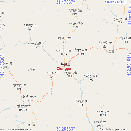
Zhanggu GPS coordinates[2]
30° 52' 7.5" North, 101° 53' 18.528" East
| Map corner | latitude | longitude |
|---|---|---|
| Upper-left | 31.47037°, | 101.18536° |
| Center: | 30.86875°, | 101.88848° |
| Lower-right: | 30.26333°, | 102.59161° |
| Map W x H: | 134.2×134.2 km | = 83.4×83.4mi |
| max Lat: | 53.31946° ⇑46.4% North |
| Zhanggu: | 30.86875° |
| min Lat: | ⇓53.6% South 18.22056° |
| min Long | Zhanggu | max Long |
| 75.07348° | 101.88848° | 134.28917° |
| W 7%⇐ | ⇒93% E |
Elevation
Elevation of Zhanggu is 2425 m = 7956 ft, and this is 1940.2 m = 6365 ft above average elevation for this country.
| Max E: |
5622 m = 18445 ft | 4.2% |
| Zhanggu | 2425 m 7956 ft | |
| Avg. | 484.8 m = 1591 ft | |
Min E: |
-3 m = -10 ft | 95.8% |
See also: China elevation on elevation.city.
Geographical zone
Zhanggu is located in North temperate zone (between Tropic of Cancer and the Arctic Circle). Distance of this Northern Tropic circle is 826.4 km =513.5 mi to South.| Distance of | km | miles | from Zhanggu |
|---|---|---|---|
| North Pole | 6574.8 | 4085.4 | to North |
| Arctic Circle | 3968.9 | 2466.2 | to North |
| Tropic Cancer | 826.4 | 513.5 | to South |
| Equator | 3432.3 | 2132.7 | to South |


Nearby cities:
15 places around Zhanggu: (largest is in red/bold)
• Barkam
119 km =73.9 mi,  15°
15°
• Guangsheng
170.7 km =106.1 mi,  94°
94°
• Jinchuan
69.4 km =43.1 mi,  13°
13°
• Kangding
96.6 km =60 mi,  176°
176°
• Linqiong
158.6 km =98.5 mi,  108°
108°
• Luhua
169.2 km =105.1 mi,  38°
38°
• Luqiao
109.2 km =67.9 mi,  162°
162°
• Meixing
47.3 km =29.4 mi,  72°
72°
• Muping
104.3 km =64.8 mi,  122°
122°
• Rulong
150.7 km =93.6 mi,  273°
273°
• Xianshui
73.9 km =45.9 mi,  280°
280°
• Xindou
129.2 km =80.3 mi,  296°
296°
• Yucheng
144.9 km =90 mi,  132°
132°
• Zagunao
138.4 km =86 mi,  62°
62°
• Zitong
173.2 km =107.6 mi, 94°
Sources, notices
• [Note1] Compared only with cities in China existing in our database
• [Src1] Map data: © OpenStreetMap contributors (CC-BY-SA)
• [Src2] Other city data from geonames.org with taken over terms of usage.
• [Src3] Geographical zone / Annual Mean Temperature by Robert A. Rohde @ Wikipedia
