Luqiao geodata
Luqiao (Sichuan) is a seat of a third-order administrative division; located in China in Asia/Shanghai (GMT+8) time zone. In our database, there are 1268 cities with bigger population. Compared to other cities in China, 54.7% of cities are located further ↑North; 92.6% of cities are located further →East and 90.6% of cities have lower elevation than Luqiao. Note1


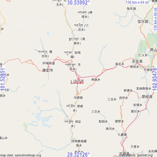
Luqiao GPS coordinates[2]
29° 55' 56.856" North, 102° 13' 53.868" East
| Map corner | latitude | longitude |
|---|---|---|
| Upper-left | 30.53992°, | 101.52851° |
| Center: | 29.93246°, | 102.23163° |
| Lower-right: | 29.32126°, | 102.93476° |
| Map W x H: | 135.5×135.5 km | = 84.2×84.2mi |
| max Lat: | 53.31946° ⇑54.7% North |
| Luqiao: | 29.93246° |
| min Lat: | ⇓45.3% South 18.22056° |
| min Long | Luqiao | max Long |
| 75.07348° | 102.23163° | 134.28917° |
| W 7.4%⇐ | ⇒92.6% E |
Elevation
Elevation of Luqiao is 1414 m = 4639 ft, and this is 929.2 m = 3049 ft above average elevation for this country.
| Max E: |
5622 m = 18445 ft | 9.4% |
| Luqiao | 1414 m 4639 ft | |
| Avg. | 484.8 m = 1591 ft | |
Min E: |
-3 m = -10 ft | 90.6% |
See also: China elevation on elevation.city.
Geographical zone
Luqiao is located in North temperate zone (between Tropic of Cancer and the Arctic Circle). Distance of this Northern Tropic circle is 722.3 km =448.8 mi to South.| Distance of | km | miles | from Luqiao |
|---|---|---|---|
| North Pole | 6678.9 | 4150.1 | to North |
| Arctic Circle | 4073 | 2530.8 | to North |
| Tropic Cancer | 722.3 | 448.8 | to South |
| Equator | 3328.2 | 2068 | to South |


Nearby cities:
15 places around Luqiao: (largest is in red/bold)
• Hepingyizu
112.2 km =69.7 mi,  132°
132°
• Kangding
27.6 km =17.1 mi,  286°
286°
• Linqiong
129.8 km =80.7 mi,  65°
65°
• Meixing
119.2 km =74.1 mi,  5°
5°
• Muping
74.1 km =46 mi,  48°
48°
• Nan’an
122.8 km =76.3 mi,  97°
97°
• Shaping
126.8 km =78.8 mi, 127°
• Shirong
76.4 km =47.5 mi,  147°
147°
• Suishan
126.3 km =78.5 mi,  106°
106°
• Xia’er
124.2 km =77.2 mi,  213°
213°
• Xinmian
78.2 km =48.6 mi,  169°
169°
• Xinshiba
119 km =73.9 mi, 153°
• Yancheng
130.5 km =81.1 mi, 99°
• Yucheng
74.2 km =46.1 mi,  85°
85°
• Zhanggu
109.2 km =67.9 mi,  342°
342°
Sources, notices
• [Note1] Compared only with cities in China existing in our database
• [Src1] Map data: © OpenStreetMap contributors (CC-BY-SA)
• [Src2] Other city data from geonames.org with taken over terms of usage.
• [Src3] Geographical zone / Annual Mean Temperature by Robert A. Rohde @ Wikipedia
