Yaolu geodata
Yaolu (Guizhou) is a populated place; located in China in Asia/Shanghai (GMT+8) time zone. With population of 923 people, there are 1193 cities with bigger population in this country. Compared to other cities in China, 84.4% of cities are located further ↑North; 80.4% of cities are located further →East and 78.9% of cities have lower elevation than Yaolu. Note1


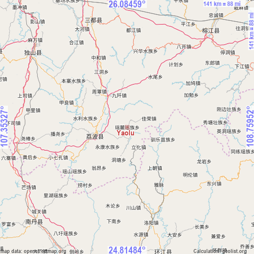
Yaolu GPS coordinates[2]
25° 27' 5.004" North, 108° 3' 23.004" East
| Map corner | latitude | longitude |
|---|---|---|
| Upper-left | 26.08459°, | 107.35327° |
| Center: | 25.45139°, | 108.05639° |
| Lower-right: | 24.81484°, | 108.75952° |
| Map W x H: | 141.2×141.2 km | = 87.7×87.7mi |
| max Lat: | 53.31946° ⇑84.4% North |
| Yaolu: | 25.45139° |
| min Lat: | ⇓15.6% South 18.22056° |
| min Long | Yaolu | max Long |
| 75.07348° | 108.05639° | 134.28917° |
| W 19.6%⇐ | ⇒80.4% E |
Elevation
Elevation of Yaolu is 648 m = 2126 ft, and this is 163.2 m = 535 ft above average elevation for this country.
| Max E: |
5622 m = 18445 ft | 21.1% |
| Yaolu | 648 m 2126 ft | |
| Avg. | 484.8 m = 1591 ft | |
Min E: |
-3 m = -10 ft | 78.9% |
See also: China elevation on elevation.city.
Geographical zone
Yaolu is located in North temperate zone (between Tropic of Cancer and the Arctic Circle). Distance of this Northern Tropic circle is 224 km =139.2 mi to South.| Distance of | km | miles | from Yaolu |
|---|---|---|---|
| North Pole | 7177.1 | 4459.6 | to North |
| Arctic Circle | 4571.2 | 2840.4 | to North |
| Tropic Cancer | 224 | 139.2 | to South |
| Equator | 2829.9 | 1758.4 | to South |


Nearby cities:
15 places around Yaolu: (largest is in red/bold)
• Chuanshan
42.9 km =26.7 mi,  176°
176°
• Darong
89.1 km =55.4 mi,  65°
65°
• Dingdan
49.7 km =30.9 mi,  25°
25°
• Gaowu
86.3 km =53.6 mi,  81°
81°
• Gaozeng
96.5 km =60 mi, 66°
• Maolan
7.1 km =4.4 mi,  164°
164°
• Nandan Chengguanzhen
70.2 km =43.6 mi,  225°
225°
• Pingjiang
67 km =41.6 mi, 30°
• Pingjiang
72.7 km =45.2 mi,  56°
56°
• Shangjiang
54.9 km =34.1 mi,  5°
5°
• Si’en
71.1 km =44.2 mi, 162°
• Tingdong
69.5 km =43.2 mi,  53°
53°
• Xiajiang
72.1 km =44.8 mi, 62°
• Xiaoweizhai
98.6 km =61.3 mi,  326°
326°
• Xishan
94.7 km =58.8 mi, 74°
Sources, notices
• [Note1] Compared only with cities in China existing in our database
• [Src1] Map data: © OpenStreetMap contributors (CC-BY-SA)
• [Src2] Other city data from geonames.org with taken over terms of usage.
• [Src3] Geographical zone / Annual Mean Temperature by Robert A. Rohde @ Wikipedia
