Shangjiang geodata
Shangjiang (Guizhou) is a populated place; located in China in Asia/Shanghai (GMT+8) time zone. With population of 781 people, there are 1220 cities with bigger population in this country. Compared to other cities in China, 82.6% of cities are located further ↑North; 80.2% of cities are located further →East and 80.9% of cities have lower elevation than Shangjiang. Note1


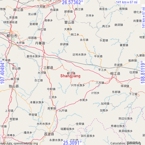
Shangjiang GPS coordinates[2]
25° 56' 35.016" North, 108° 6' 29.016" East
| Map corner | latitude | longitude |
|---|---|---|
| Upper-left | 26.57362°, | 107.40494° |
| Center: | 25.94306°, | 108.10806° |
| Lower-right: | 25.3091°, | 108.81119° |
| Map W x H: | 140.6×140.6 km | = 87.4×87.4mi |
| max Lat: | 53.31946° ⇑82.6% North |
| Shangjiang: | 25.94306° |
| min Lat: | ⇓17.4% South 18.22056° |
| min Long | Shangjiang | max Long |
| 75.07348° | 108.10806° | 134.28917° |
| W 19.8%⇐ | ⇒80.2% E |
Elevation
Elevation of Shangjiang is 737 m = 2418 ft, and this is 252.2 m = 827 ft above average elevation for this country.
| Max E: |
5622 m = 18445 ft | 19.1% |
| Shangjiang | 737 m 2418 ft | |
| Avg. | 484.8 m = 1591 ft | |
Min E: |
-3 m = -10 ft | 80.9% |
See also: China elevation on elevation.city.
Geographical zone
Shangjiang is located in North temperate zone (between Tropic of Cancer and the Arctic Circle). Distance of this Northern Tropic circle is 278.7 km =173.2 mi to South.| Distance of | km | miles | from Shangjiang |
|---|---|---|---|
| North Pole | 7122.5 | 4425.7 | to North |
| Arctic Circle | 4516.6 | 2806.5 | to North |
| Tropic Cancer | 278.7 | 173.2 | to South |
| Equator | 2884.6 | 1792.4 | to South |


Nearby cities:
15 places around Shangjiang: (largest is in red/bold)
• Chuanshan
97.5 km =60.6 mi,  181°
181°
• Darong
77.6 km =48.2 mi,  103°
103°
• Dingdan
18.7 km =11.6 mi,  121°
121°
• Duyun
69.1 km =42.9 mi,  301°
301°
• Gaowu
90.6 km =56.3 mi, 117°
• Gaozeng
84.5 km =52.5 mi, 100°
• Maolan
61.6 km =38.3 mi, 183°
• Pingjiang
28.9 km =18 mi,  83°
83°
• Pingjiang
57.3 km =35.6 mi, 104°
• Shuangjiang
81.6 km =50.7 mi,  88°
88°
• Tingdong
52.2 km =32.4 mi, 104°
• Xiajiang
62 km =38.5 mi,  109°
109°
• Xiaoweizhai
65.5 km =40.7 mi,  294°
294°
• Xishan
90.3 km =56.1 mi, 108°
• Yaolu
54.9 km =34.1 mi,  185°
185°
Sources, notices
• [Note1] Compared only with cities in China existing in our database
• [Src1] Map data: © OpenStreetMap contributors (CC-BY-SA)
• [Src2] Other city data from geonames.org with taken over terms of usage.
• [Src3] Geographical zone / Annual Mean Temperature by Robert A. Rohde @ Wikipedia
