Lingcheng geodata
Lingcheng (Shandong) is a seat of a third-order administrative division; located in China in Asia/Shanghai (GMT+8) time zone. In our database, there are 1268 cities with bigger population. Compared to other cities in China, 76.1% of cities are located further ↓South; 65.5% of cities are located further ←West and 68.4% of cities have higher elevation than Lingcheng. Note1


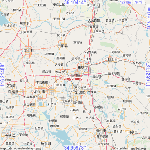
Lingcheng GPS coordinates[2]
35° 32' 2.4" North, 116° 55' 4.8" East
| Map corner | latitude | longitude |
|---|---|---|
| Upper-left | 36.10414°, | 116.21488° |
| Center: | 35.534°, | 116.918° |
| Lower-right: | 34.95978°, | 117.62113° |
| Map W x H: | 127.2×127.2 km | = 79×79mi |
| max Lat: | 53.31946° ⇑23.9% North |
| Lingcheng: | 35.534° |
| min Lat: | ⇓76.1% South 18.22056° |
| min Long | Lingcheng | max Long |
| 75.07348° | 116.918° | 134.28917° |
| W 65.5%⇐ | ⇒34.5% E |
Elevation
Elevation of Lingcheng is 58 m = 190 ft, and this is 426.8 m = 1400 ft below average elevation for this country.
| Max E: |
5622 m = 18445 ft | 68.4% |
| Avg. | 484.8 m = 1591 ft | |
| Lingcheng | 58 m = 190 ft | |
Min E: |
-3 m = -10 ft | 31.6% |
See also: China elevation on elevation.city.
Geographical zone
Lingcheng is located in North temperate zone (between Tropic of Cancer and the Arctic Circle). Distance of this Northern Tropic circle is 1345.1 km =835.8 mi to South.| Distance of | km | miles | from Lingcheng |
|---|---|---|---|
| North Pole | 6056.1 | 3763.1 | to North |
| Arctic Circle | 3450.2 | 2143.9 | to North |
| Tropic Cancer | 1345.1 | 835.8 | to South |
| Equator | 3951 | 2455 | to South |


Nearby cities:
15 places around Lingcheng: (largest is in red/bold)
• Chengtangcun
55.9 km =34.7 mi,  153°
153°
• Dongdu
78.9 km =49 mi,  63°
63°
• Jiaxiang
53.8 km =33.4 mi,  253°
253°
• Jining
33.7 km =20.9 mi,  244°
244°
• Juye
76.7 km =47.7 mi,  258°
258°
• Ningyang
28 km =17.4 mi,  335°
335°
• Pingyi
64.6 km =40.1 mi,  93°
93°
• Qufu
9.6 km =6 mi,  43°
43°
• Shanting
70.7 km =43.9 mi,  136°
136°
• Sishui
34.8 km =21.6 mi,  68°
68°
• Tai’an
74.7 km =46.4 mi,  14°
14°
• Wenshang
43.8 km =27.2 mi,  299°
299°
• Yanzhou
8.4 km =5.2 mi,  284°
284°
• Zhoucheng
69 km =42.9 mi,  307°
307°
• Zoucheng
15.4 km =9.6 mi,  163°
163°
Sources, notices
• [Note1] Compared only with cities in China existing in our database
• [Src1] Map data: © OpenStreetMap contributors (CC-BY-SA)
• [Src2] Other city data from geonames.org with taken over terms of usage.
• [Src3] Geographical zone / Annual Mean Temperature by Robert A. Rohde @ Wikipedia
