Sishui geodata
Sishui (Shandong) is a populated place; located in China in Asia/Shanghai (GMT+8) time zone. With population of 90,175 people, there are 473 cities with bigger population in this country. Compared to other cities in China, 76.4% of cities are located further ↓South; 67.7% of cities are located further ←West and 57.9% of cities have higher elevation than Sishui. Note1


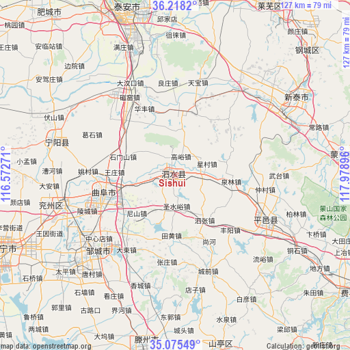
Sishui GPS coordinates[2]
35° 38' 56.004" North, 117° 16' 32.988" East
| Map corner | latitude | longitude |
|---|---|---|
| Upper-left | 36.2182°, | 116.57271° |
| Center: | 35.64889°, | 117.27583° |
| Lower-right: | 35.07549°, | 117.97896° |
| Map W x H: | 127.1×127.1 km | = 79×79mi |
| max Lat: | 53.31946° ⇑23.6% North |
| Sishui: | 35.64889° |
| min Lat: | ⇓76.4% South 18.22056° |
| min Long | Sishui | max Long |
| 75.07348° | 117.27583° | 134.28917° |
| W 67.7%⇐ | ⇒32.3% E |
Elevation
Elevation of Sishui is 112 m = 367 ft, and this is 372.8 m = 1223 ft below average elevation for this country.
| Max E: |
5622 m = 18445 ft | 57.9% |
| Avg. | 484.8 m = 1591 ft | |
| Sishui | 112 m = 367 ft | |
Min E: |
-3 m = -10 ft | 42.1% |
See also: Sishui elevation on elevation.city.
Geographical zone
Sishui is located in North temperate zone (between Tropic of Cancer and the Arctic Circle). Distance of this Northern Tropic circle is 1357.9 km =843.8 mi to South.| Distance of | km | miles | from Sishui |
|---|---|---|---|
| North Pole | 6043.3 | 3755.1 | to North |
| Arctic Circle | 3437.4 | 2135.9 | to North |
| Tropic Cancer | 1357.9 | 843.8 | to South |
| Equator | 3963.8 | 2463 | to South |


Nearby cities:
15 places around Sishui: (largest is in red/bold)
• Chengtangcun
63.3 km =39.3 mi,  186°
186°
• Dongdu
44.3 km =27.5 mi,  59°
59°
• Jining
68.4 km =42.5 mi,  246°
246°
• Laiwu
69.5 km =43.2 mi,  29°
29°
• Lingcheng
34.8 km =21.6 mi, 248°
• Mengyin
59.1 km =36.7 mi,  83°
83°
• Ningyang
45.6 km =28.3 mi,  286°
286°
• Pingyi
36.1 km =22.4 mi,  117°
117°
• Qufu
26.4 km =16.4 mi,  257°
257°
• Shanting
65.9 km =40.9 mi,  165°
165°
• Tai’an
61.3 km =38.1 mi,  346°
346°
• Wenshang
71 km =44.1 mi,  277°
277°
• Xintai
51.3 km =31.9 mi, 56°
• Yanzhou
41.8 km =26 mi, 255°
• Zoucheng
39.4 km =24.5 mi,  225°
225°
Sources, notices
• [Note1] Compared only with cities in China existing in our database
• [Src1] Map data: © OpenStreetMap contributors (CC-BY-SA)
• [Src2] Other city data from geonames.org with taken over terms of usage.
• [Src3] Geographical zone / Annual Mean Temperature by Robert A. Rohde @ Wikipedia
