Tai’an geodata
Tai’an (Shandong) is a populated place; located in China in Asia/Shanghai (GMT+8) time zone. With population of 5,499,000 people, there are 15 cities with bigger population in this country. Compared to other cities in China, 77.6% of cities are located further ↓South; 66.6% of cities are located further ←West and 53.1% of cities have higher elevation than Tai’an. Note1


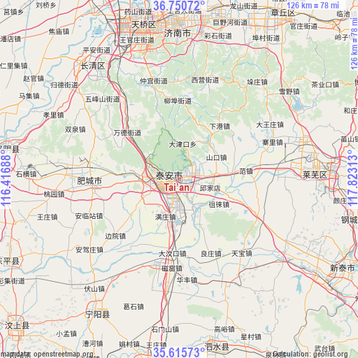
Tai’an GPS coordinates[2]
36° 11' 7.008" North, 117° 7' 12" East
| Map corner | latitude | longitude |
|---|---|---|
| Upper-left | 36.75072°, | 116.41688° |
| Center: | 36.18528°, | 117.12° |
| Lower-right: | 35.61573°, | 117.82313° |
| Map W x H: | 126.2×126.2 km | = 78.4×78.4mi |
| max Lat: | 53.31946° ⇑22.4% North |
| Tai’an: | 36.18528° |
| min Lat: | ⇓77.6% South 18.22056° |
| min Long | Tai’an | max Long |
| 75.07348° | 117.12° | 134.28917° |
| W 66.6%⇐ | ⇒33.4% E |
Elevation
Elevation of Tai’an is 143 m = 469 ft, and this is 341.8 m = 1121 ft below average elevation for this country.
| Max E: |
5622 m = 18445 ft | 53.1% |
| Avg. | 484.8 m = 1591 ft | |
| Tai’an | 143 m = 469 ft | |
Min E: |
-3 m = -10 ft | 46.9% |
See also: Tai’an elevation on elevation.city.
Geographical zone
Tai’an is located in North temperate zone (between Tropic of Cancer and the Arctic Circle). Distance of this Northern Tropic circle is 1417.5 km =880.8 mi to South.| Distance of | km | miles | from Tai’an |
|---|---|---|---|
| North Pole | 5983.6 | 3718 | to North |
| Arctic Circle | 3377.7 | 2098.8 | to North |
| Tropic Cancer | 1417.5 | 880.8 | to South |
| Equator | 4023.4 | 2500 | to South |


Nearby cities:
15 places around Tai’an: (largest is in red/bold)
• Boshan
72 km =44.7 mi,  62°
62°
• Changqing
54.3 km =33.7 mi,  319°
319°
• Dongdu
64.1 km =39.8 mi,  125°
125°
• Feicheng
32.5 km =20.2 mi,  282°
282°
• Jinan
54.8 km =34.1 mi,  348°
348°
• Laiwu
48.2 km =30 mi,  89°
89°
• Lingcheng
74.7 km =46.4 mi,  194°
194°
• Mingshui
68.2 km =42.4 mi,  29°
29°
• Ningyang
55.4 km =34.4 mi,  212°
212°
• Pingyin
61.5 km =38.2 mi, 280°
• Qufu
66.5 km =41.3 mi, 190°
• Sishui
61.3 km =38.1 mi,  166°
166°
• Wenshang
75.8 km =47.1 mi,  227°
227°
• Xintai
65 km =40.4 mi,  119°
119°
• Yanzhou
75.1 km =46.7 mi,  200°
200°
Sources, notices
• [Note1] Compared only with cities in China existing in our database
• [Src1] Map data: © OpenStreetMap contributors (CC-BY-SA)
• [Src2] Other city data from geonames.org with taken over terms of usage.
• [Src3] Geographical zone / Annual Mean Temperature by Robert A. Rohde @ Wikipedia
