Qufu geodata
Qufu (Shandong) is a populated place; located in China in Asia/Shanghai (GMT+8) time zone. With population of 85,144 people, there are 501 cities with bigger population in this country. Compared to other cities in China, 76.2% of cities are located further ↓South; 65.9% of cities are located further ←West and 65.8% of cities have higher elevation than Qufu. Note1


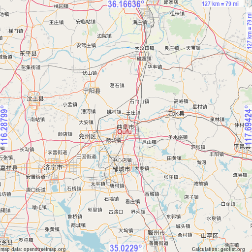
Qufu GPS coordinates[2]
35° 35' 48.012" North, 116° 59' 27.996" East
| Map corner | latitude | longitude |
|---|---|---|
| Upper-left | 36.16636°, | 116.28799° |
| Center: | 35.59667°, | 116.99111° |
| Lower-right: | 35.0229°, | 117.69424° |
| Map W x H: | 127.1×127.1 km | = 79×79mi |
| max Lat: | 53.31946° ⇑23.8% North |
| Qufu: | 35.59667° |
| min Lat: | ⇓76.2% South 18.22056° |
| min Long | Qufu | max Long |
| 75.07348° | 116.99111° | 134.28917° |
| W 65.9%⇐ | ⇒34.1% E |
Elevation
Elevation of Qufu is 69 m = 226 ft, and this is 415.8 m = 1364 ft below average elevation for this country.
| Max E: |
5622 m = 18445 ft | 65.8% |
| Avg. | 484.8 m = 1591 ft | |
| Qufu | 69 m = 226 ft | |
Min E: |
-3 m = -10 ft | 34.2% |
See also: Qufu elevation on elevation.city.
Geographical zone
Qufu is located in North temperate zone (between Tropic of Cancer and the Arctic Circle). Distance of this Northern Tropic circle is 1352.1 km =840.2 mi to South.| Distance of | km | miles | from Qufu |
|---|---|---|---|
| North Pole | 6049.1 | 3758.7 | to North |
| Arctic Circle | 3443.2 | 2139.5 | to North |
| Tropic Cancer | 1352.1 | 840.2 | to South |
| Equator | 3958 | 2459.4 | to South |


Nearby cities:
15 places around Qufu: (largest is in red/bold)
• Chengtangcun
59.9 km =37.2 mi,  162°
162°
• Dongdu
69.9 km =43.4 mi,  66°
66°
• Feicheng
75.3 km =46.8 mi,  344°
344°
• Jiaxiang
62.3 km =38.7 mi,  249°
249°
• Jining
42.8 km =26.6 mi,  240°
240°
• Lingcheng
9.6 km =6 mi,  223°
223°
• Ningyang
25.9 km =16.1 mi,  315°
315°
• Pingyi
58.9 km =36.6 mi,  100°
100°
• Shanting
71.8 km =44.6 mi,  143°
143°
• Sishui
26.4 km =16.4 mi,  77°
77°
• Tai’an
66.5 km =41.3 mi,  10°
10°
• Wenshang
47 km =29.2 mi,  288°
288°
• Yanzhou
15.5 km =9.6 mi, 251°
• Zhoucheng
70.6 km =43.9 mi,  299°
299°
• Zoucheng
21.9 km =13.6 mi,  186°
186°
Sources, notices
• [Note1] Compared only with cities in China existing in our database
• [Src1] Map data: © OpenStreetMap contributors (CC-BY-SA)
• [Src2] Other city data from geonames.org with taken over terms of usage.
• [Src3] Geographical zone / Annual Mean Temperature by Robert A. Rohde @ Wikipedia
