Pingyi geodata
Pingyi (Shandong) is a populated place; located in China in Asia/Shanghai (GMT+8) time zone. With population of 78,254 people, there are 545 cities with bigger population in this country. Compared to other cities in China, 76% of cities are located further ↓South; 69.2% of cities are located further ←West and 51.3% of cities have higher elevation than Pingyi. Note1


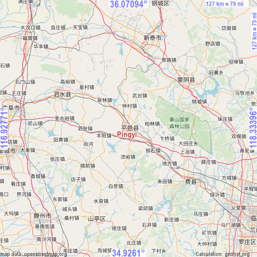
Pingyi GPS coordinates[2]
35° 30' 2.016" North, 117° 37' 50.988" East
| Map corner | latitude | longitude |
|---|---|---|
| Upper-left | 36.07094°, | 116.92771° |
| Center: | 35.50056°, | 117.63083° |
| Lower-right: | 34.9261°, | 118.33396° |
| Map W x H: | 127.3×127.3 km | = 79.1×79.1mi |
| max Lat: | 53.31946° ⇑24% North |
| Pingyi: | 35.50056° |
| min Lat: | ⇓76% South 18.22056° |
| min Long | Pingyi | max Long |
| 75.07348° | 117.63083° | 134.28917° |
| W 69.2%⇐ | ⇒30.8% E |
Elevation
Elevation of Pingyi is 154 m = 505 ft, and this is 330.8 m = 1085 ft below average elevation for this country.
| Max E: |
5622 m = 18445 ft | 51.3% |
| Avg. | 484.8 m = 1591 ft | |
| Pingyi | 154 m = 505 ft | |
Min E: |
-3 m = -10 ft | 48.7% |
See also: Pingyi elevation on elevation.city.
Geographical zone
Pingyi is located in North temperate zone (between Tropic of Cancer and the Arctic Circle). Distance of this Northern Tropic circle is 1341.4 km =833.5 mi to South.| Distance of | km | miles | from Pingyi |
|---|---|---|---|
| North Pole | 6059.8 | 3765.4 | to North |
| Arctic Circle | 3453.9 | 2146.2 | to North |
| Tropic Cancer | 1341.4 | 833.5 | to South |
| Equator | 3947.3 | 2452.7 | to South |


Nearby cities:
15 places around Pingyi: (largest is in red/bold)
• Chengtangcun
61.2 km =38 mi,  220°
220°
• Dongdu
39.4 km =24.5 mi,  9°
9°
• Feicheng
40.5 km =25.2 mi,  131°
131°
• Jiehu
74.7 km =46.4 mi,  86°
86°
• Laiwu
77 km =47.8 mi,  1°
1°
• Lingcheng
64.6 km =40.1 mi,  273°
273°
• Mengyin
35.2 km =21.9 mi,  49°
49°
• Qufu
58.9 km =36.6 mi,  280°
280°
• Shanting
49.8 km =30.9 mi,  198°
198°
• Sishui
36.1 km =22.4 mi,  297°
297°
• Taozhuang
77.2 km =48 mi, 200°
• Xintai
45.8 km =28.5 mi, 13°
• Yanzhou
72.8 km =45.2 mi, 274°
• Zaozhuang
71 km =44.1 mi,  185°
185°
• Zoucheng
61.3 km =38.1 mi,  259°
259°
Sources, notices
• [Note1] Compared only with cities in China existing in our database
• [Src1] Map data: © OpenStreetMap contributors (CC-BY-SA)
• [Src2] Other city data from geonames.org with taken over terms of usage.
• [Src3] Geographical zone / Annual Mean Temperature by Robert A. Rohde @ Wikipedia
