Xamba geodata
Xamba (Inner Mongolia) is a seat of a third-order administrative division; located in China in Asia/Shanghai (GMT+8) time zone. In our database, there are 1268 cities with bigger population. Compared to other cities in China, 88.9% of cities are located further ↓South; 83.3% of cities are located further →East and 85.9% of cities have lower elevation than Xamba. Note1


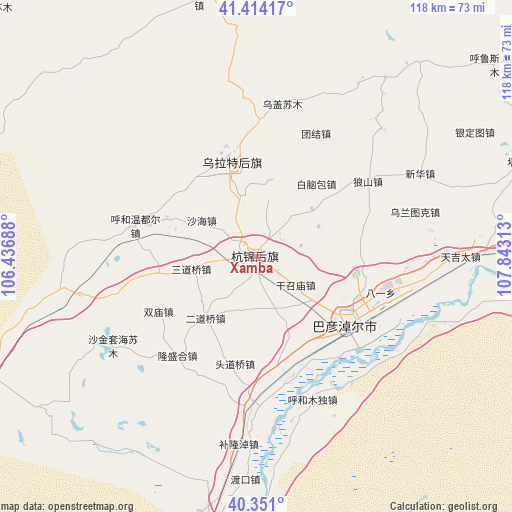
Xamba GPS coordinates[2]
40° 53' 4.992" North, 107° 8' 24" East
| Map corner | latitude | longitude |
|---|---|---|
| Upper-left | 41.41417°, | 106.43688° |
| Center: | 40.88472°, | 107.14° |
| Lower-right: | 40.351°, | 107.84313° |
| Map W x H: | 118.2×118.2 km | = 73.4×73.4mi |
| max Lat: | 53.31946° ⇑11.1% North |
| Xamba: | 40.88472° |
| min Lat: | ⇓88.9% South 18.22056° |
| min Long | Xamba | max Long |
| 75.07348° | 107.14° | 134.28917° |
| W 16.7%⇐ | ⇒83.3% E |
Elevation
Elevation of Xamba is 1038 m = 3406 ft, and this is 553.2 m = 1815 ft above average elevation for this country.
| Max E: |
5622 m = 18445 ft | 14.1% |
| Xamba | 1038 m 3406 ft | |
| Avg. | 484.8 m = 1591 ft | |
Min E: |
-3 m = -10 ft | 85.9% |
See also: China elevation on elevation.city.
Geographical zone
Xamba is located in North temperate zone (between Tropic of Cancer and the Arctic Circle). Distance of this Northern Tropic circle is 1940 km =1205.5 mi to South.| Distance of | km | miles | from Xamba |
|---|---|---|---|
| North Pole | 5461.1 | 3393.4 | to North |
| Arctic Circle | 2855.2 | 1774.1 | to North |
| Tropic Cancer | 1940 | 1205.5 | to South |
| Equator | 4546 | 2824.8 | to South |


Nearby cities:
15 places around Xamba: (largest is in red/bold)
• Bayan Gol
66.3 km =41.2 mi,  191°
191°
• Bayan Nur
26.1 km =16.2 mi,  127°
127°
• Bayinbaolige
23.8 km =14.8 mi,  344°
344°
• Bayinsai
158 km =98.2 mi, 193°
• Beijie
187.5 km =116.5 mi, 189°
• Haliut
137.4 km =85.4 mi,  57°
57°
• Lasengmiao
175.6 km =109.1 mi, 188°
• Qabqir
142.9 km =88.8 mi, 189°
• Shitanjing
195.6 km =121.5 mi,  200°
200°
• Shizuishan
186.3 km =115.8 mi, 189°
• Ulashan
137.3 km =85.3 mi,  100°
100°
• Wuda
158.3 km =98.4 mi, 193°
• Wuhai
136.3 km =84.7 mi, 191°
• Xinli
177.9 km =110.5 mi, 130°
• Xishanzui
128.1 km =79.6 mi, 98°
Sources, notices
• [Note1] Compared only with cities in China existing in our database
• [Src1] Map data: © OpenStreetMap contributors (CC-BY-SA)
• [Src2] Other city data from geonames.org with taken over terms of usage.
• [Src3] Geographical zone / Annual Mean Temperature by Robert A. Rohde @ Wikipedia
