Bayan Gol geodata
Bayan Gol (Inner Mongolia) is a seat of a third-order administrative division; located in China in Asia/Shanghai (GMT+8) time zone. In our database, there are 1268 cities with bigger population. Compared to other cities in China, 87.5% of cities are located further ↓South; 83.7% of cities are located further →East and 86.1% of cities have lower elevation than Bayan Gol. Note1


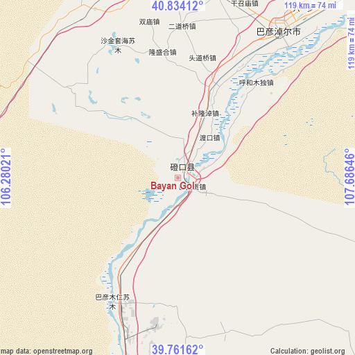
Bayan Gol GPS coordinates[2]
40° 18' 0" North, 106° 58' 59.988" East
| Map corner | latitude | longitude |
|---|---|---|
| Upper-left | 40.83412°, | 106.28021° |
| Center: | 40.3°, | 106.98333° |
| Lower-right: | 39.76162°, | 107.68646° |
| Map W x H: | 119.3×119.2 km | = 74.1×74.1mi |
| max Lat: | 53.31946° ⇑12.5% North |
| Bayan Gol: | 40.3° |
| min Lat: | ⇓87.5% South 18.22056° |
| min Long | Bayan Gol | max Long |
| 75.07348° | 106.98333° | 134.28917° |
| W 16.3%⇐ | ⇒83.7% E |
Elevation
Elevation of Bayan Gol is 1053 m = 3455 ft, and this is 568.2 m = 1864 ft above average elevation for this country.
| Max E: |
5622 m = 18445 ft | 13.9% |
| Bayan Gol | 1053 m 3455 ft | |
| Avg. | 484.8 m = 1591 ft | |
Min E: |
-3 m = -10 ft | 86.1% |
See also: China elevation on elevation.city.
Geographical zone
Bayan Gol is located in North temperate zone (between Tropic of Cancer and the Arctic Circle). Distance of this Northern Tropic circle is 1875 km =1165.1 mi to South.| Distance of | km | miles | from Bayan Gol |
|---|---|---|---|
| North Pole | 5526.1 | 3433.8 | to North |
| Arctic Circle | 2920.2 | 1814.5 | to North |
| Tropic Cancer | 1875 | 1165.1 | to South |
| Equator | 4480.9 | 2784.3 | to South |


Nearby cities:
15 places around Bayan Gol: (largest is in red/bold)
• Bayan Nur
59.7 km =37.1 mi,  34°
34°
• Bayinbaolige
88.3 km =54.9 mi,  4°
4°
• Bayinsai
91.7 km =57 mi,  194°
194°
• Beijie
121.2 km =75.3 mi, 188°
• Dawukou
148.6 km =92.3 mi,  199°
199°
• Lasengmiao
109.4 km =68 mi, 186°
• Qabqir
76.6 km =47.6 mi, 187°
• Shitanjing
130.5 km =81.1 mi, 204°
• Shizuishan
120 km =74.6 mi, 188°
• Ulashan
154.4 km =95.9 mi,  74°
74°
• Wuda
92 km =57.2 mi, 194°
• Wuhai
69.9 km =43.4 mi, 191°
• Xamba
66.3 km =41.2 mi,  11°
11°
• Xinli
157.4 km =97.8 mi,  108°
108°
• Xishanzui
147.5 km =91.7 mi, 72°
Sources, notices
• [Note1] Compared only with cities in China existing in our database
• [Src1] Map data: © OpenStreetMap contributors (CC-BY-SA)
• [Src2] Other city data from geonames.org with taken over terms of usage.
• [Src3] Geographical zone / Annual Mean Temperature by Robert A. Rohde @ Wikipedia
