Bayan Nur geodata
Bayan Nur (Inner Mongolia) is a populated place; located in China in Asia/Shanghai (GMT+8) time zone. With population of 1,760,000 people, there are 45 cities with bigger population in this country. Compared to other cities in China, 88.6% of cities are located further ↓South; 82.5% of cities are located further →East and 86.1% of cities have lower elevation than Bayan Nur. Note1


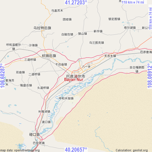
Bayan Nur GPS coordinates[2]
40° 44' 29.148" North, 107° 23' 9.564" East
| Map corner | latitude | longitude |
|---|---|---|
| Upper-left | 41.27203°, | 106.68287° |
| Center: | 40.74143°, | 107.38599° |
| Lower-right: | 40.20657°, | 108.08912° |
| Map W x H: | 118.5×118.5 km | = 73.6×73.6mi |
| max Lat: | 53.31946° ⇑11.4% North |
| Bayan Nur: | 40.74143° |
| min Lat: | ⇓88.6% South 18.22056° |
| min Long | Bayan Nur | max Long |
| 75.07348° | 107.38599° | 134.28917° |
| W 17.5%⇐ | ⇒82.5% E |
Elevation
Elevation of Bayan Nur is 1050 m = 3445 ft, and this is 565.2 m = 1854 ft above average elevation for this country.
| Max E: |
5622 m = 18445 ft | 13.9% |
| Bayan Nur | 1050 m 3445 ft | |
| Avg. | 484.8 m = 1591 ft | |
Min E: |
-3 m = -10 ft | 86.1% |
See also: Bayan Nur elevation on elevation.city.
Geographical zone
Bayan Nur is located in North temperate zone (between Tropic of Cancer and the Arctic Circle). Distance of this Northern Tropic circle is 1924.1 km =1195.6 mi to South.| Distance of | km | miles | from Bayan Nur |
|---|---|---|---|
| North Pole | 5477 | 3403.2 | to North |
| Arctic Circle | 2871.2 | 1784.1 | to North |
| Tropic Cancer | 1924.1 | 1195.6 | to South |
| Equator | 4530 | 2814.8 | to South |


Nearby cities:
15 places around Bayan Nur: (largest is in red/bold)
• Bayan Gol
59.7 km =37.1 mi,  214°
214°
• Bayinbaolige
47.3 km =29.4 mi,  325°
325°
• Bayinsai
149.2 km =92.7 mi,  202°
202°
• Beijie
176.9 km =109.9 mi, 197°
• Haliut
131.2 km =81.5 mi,  46°
46°
• Lasengmiao
164.5 km =102.2 mi, 196°
• Qabqir
132.5 km =82.3 mi, 199°
• Shitanjing
189.6 km =117.8 mi, 207°
• Shizuishan
175.7 km =109.2 mi, 197°
• Ulashan
114.8 km =71.3 mi,  94°
94°
• Wuda
149.5 km =92.9 mi, 202°
• Wuhai
127.1 km =79 mi, 202°
• Xamba
26.1 km =16.2 mi,  307°
307°
• Xinli
151.8 km =94.3 mi,  131°
131°
• Xishanzui
106.1 km =65.9 mi, 92°
Sources, notices
• [Note1] Compared only with cities in China existing in our database
• [Src1] Map data: © OpenStreetMap contributors (CC-BY-SA)
• [Src2] Other city data from geonames.org with taken over terms of usage.
• [Src3] Geographical zone / Annual Mean Temperature by Robert A. Rohde @ Wikipedia
