Jurh geodata
Jurh (Inner Mongolia) is a seat of a fourth-order administrative division; located in China in Asia/Shanghai (GMT+8) time zone. In our database, there are 1268 cities with bigger population. Compared to other cities in China, 93.1% of cities are located further ↓South; 90.5% of cities are located further ←West and 54.1% of cities have lower elevation than Jurh. Note1


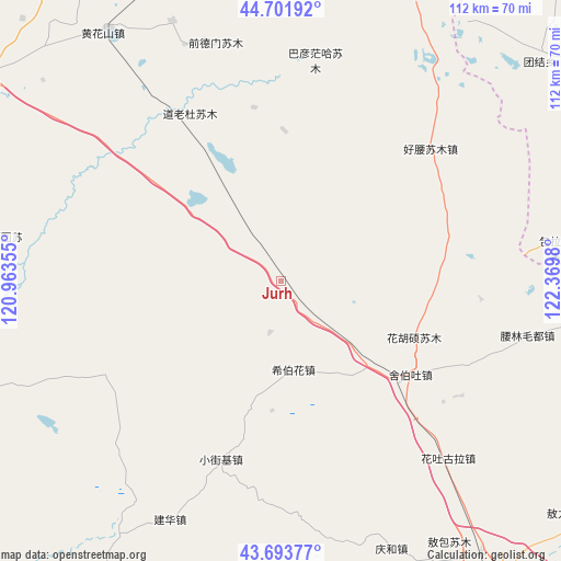
Jurh GPS coordinates[2]
44° 12' 0" North, 121° 40' 0.012" East
| Map corner | latitude | longitude |
|---|---|---|
| Upper-left | 44.70192°, | 120.96355° |
| Center: | 44.2°, | 121.66667° |
| Lower-right: | 43.69377°, | 122.3698° |
| Map W x H: | 112.1×112.1 km | = 69.7×69.7mi |
| max Lat: | 53.31946° ⇑6.9% North |
| Jurh: | 44.2° |
| min Lat: | ⇓93.1% South 18.22056° |
| min Long | Jurh | max Long |
| 75.07348° | 121.66667° | 134.28917° |
| W 90.5%⇐ | ⇒9.5% E |
Elevation
Elevation of Jurh is 198 m = 650 ft, and this is 286.8 m = 941 ft below average elevation for this country.
| Max E: |
5622 m = 18445 ft | 45.9% |
| Avg. | 484.8 m = 1591 ft | |
| Jurh | 198 m = 650 ft | |
Min E: |
-3 m = -10 ft | 54.1% |
See also: China elevation on elevation.city.
Geographical zone
Jurh is located in North temperate zone (between Tropic of Cancer and the Arctic Circle). Distance of this Northern Tropic circle is 2308.7 km =1434.6 mi to South.| Distance of | km | miles | from Jurh |
|---|---|---|---|
| North Pole | 5092.5 | 3164.3 | to North |
| Arctic Circle | 2486.6 | 1545.1 | to North |
| Tropic Cancer | 2308.7 | 1434.6 | to South |
| Equator | 4914.6 | 3053.8 | to South |


Nearby cities:
15 places around Jurh: (largest is in red/bold)
• Anding
130.4 km =81 mi,  34°
34°
• Baokang
131 km =81.4 mi,  93°
93°
• Bayan Huxu
107.7 km =66.9 mi,  348°
348°
• Bayan Tal
99.3 km =61.7 mi,  282°
282°
• Bor Ondor
58.9 km =36.6 mi,  82°
82°
• Dolod
37.5 km =23.3 mi,  332°
332°
• Gaoliban
76.7 km =47.7 mi,  7°
7°
• Kailu
78.1 km =48.5 mi,  208°
208°
• Lubei
72.5 km =45 mi,  308°
308°
• Tianshan
130.5 km =81.1 mi,  254°
254°
• Tongliao
81 km =50.3 mi,  143°
143°
• Xi Ail
118.8 km =73.8 mi,  49°
49°
• Xianghai
107.3 km =66.7 mi, 30°
• Xinfa
75.4 km =46.9 mi,  55°
55°
• Xinhua
104.4 km =64.9 mi,  65°
65°
Sources, notices
• [Note1] Compared only with cities in China existing in our database
• [Src1] Map data: © OpenStreetMap contributors (CC-BY-SA)
• [Src2] Other city data from geonames.org with taken over terms of usage.
• [Src3] Geographical zone / Annual Mean Temperature by Robert A. Rohde @ Wikipedia
