Bor Ondor geodata
Bor Ondor (Jilin) is a seat of a fourth-order administrative division; located in China in Asia/Shanghai (GMT+8) time zone. In our database, there are 1268 cities with bigger population. Compared to other cities in China, 93.1% of cities are located further ↓South; 91.9% of cities are located further ←West and 50.4% of cities have higher elevation than Bor Ondor. Note1


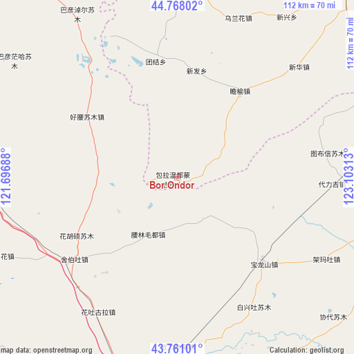
Bor Ondor GPS coordinates[2]
44° 16' 0.012" North, 122° 24' 0" East
| Map corner | latitude | longitude |
|---|---|---|
| Upper-left | 44.76802°, | 121.69688° |
| Center: | 44.26667°, | 122.4° |
| Lower-right: | 43.76101°, | 123.10313° |
| Map W x H: | 112×112 km | = 69.6×69.6mi |
| max Lat: | 53.31946° ⇑6.9% North |
| Bor Ondor: | 44.26667° |
| min Lat: | ⇓93.1% South 18.22056° |
| min Long | Bor Ondor | max Long |
| 75.07348° | 122.4° | 134.28917° |
| W 91.9%⇐ | ⇒8.1% E |
Elevation
Elevation of Bor Ondor is 161 m = 528 ft, and this is 323.8 m = 1062 ft below average elevation for this country.
| Max E: |
5622 m = 18445 ft | 50.4% |
| Avg. | 484.8 m = 1591 ft | |
| Bor Ondor | 161 m = 528 ft | |
Min E: |
-3 m = -10 ft | 49.6% |
See also: China elevation on elevation.city.
Geographical zone
Bor Ondor is located in North temperate zone (between Tropic of Cancer and the Arctic Circle). Distance of this Northern Tropic circle is 2316.1 km =1439.2 mi to South.| Distance of | km | miles | from Bor Ondor |
|---|---|---|---|
| North Pole | 5085.1 | 3159.7 | to North |
| Arctic Circle | 2479.2 | 1540.5 | to North |
| Tropic Cancer | 2316.1 | 1439.2 | to South |
| Equator | 4922 | 3058.4 | to South |


Nearby cities:
15 places around Bor Ondor: (largest is in red/bold)
• Anding
101.3 km =62.9 mi,  8°
8°
• Baokang
74 km =46 mi,  102°
102°
• Dolod
79.8 km =49.6 mi,  288°
288°
• Gaoliban
83.4 km =51.8 mi,  325°
325°
• Guangming
122.4 km =76.1 mi, 14°
• Heishui
108.9 km =67.7 mi,  17°
17°
• Jurh
58.9 km =36.6 mi,  262°
262°
• Kaitong
85 km =52.8 mi,  44°
44°
• Lubei
120.8 km =75.1 mi, 288°
• Shuanggang
102.1 km =63.4 mi, 23°
• Tongliao
73.5 km =45.7 mi,  188°
188°
• Xi Ail
77.2 km =48 mi, 24°
• Xianghai
85.3 km =53 mi,  357°
357°
• Xinfa
35.4 km =22 mi, 6°
• Xinhua
51.1 km =31.8 mi,  46°
46°
Sources, notices
• [Note1] Compared only with cities in China existing in our database
• [Src1] Map data: © OpenStreetMap contributors (CC-BY-SA)
• [Src2] Other city data from geonames.org with taken over terms of usage.
• [Src3] Geographical zone / Annual Mean Temperature by Robert A. Rohde @ Wikipedia
