Simenzi geodata
Simenzi (Liaoning) is a seat of a fourth-order administrative division; located in China in Asia/Shanghai (GMT+8) time zone. In our database, there are 1268 cities with bigger population. Compared to other cities in China, 88.6% of cities are located further ↓South; 93.6% of cities are located further ←West and 58.7% of cities have lower elevation than Simenzi. Note1


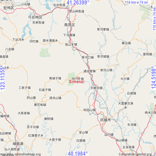
Simenzi GPS coordinates[2]
40° 43' 59.988" North, 123° 49' 0.012" East
| Map corner | latitude | longitude |
|---|---|---|
| Upper-left | 41.26399°, | 123.11355° |
| Center: | 40.73333°, | 123.81667° |
| Lower-right: | 40.1984°, | 124.5198° |
| Map W x H: | 118.5×118.5 km | = 73.6×73.6mi |
| max Lat: | 53.31946° ⇑11.4% North |
| Simenzi: | 40.73333° |
| min Lat: | ⇓88.6% South 18.22056° |
| min Long | Simenzi | max Long |
| 75.07348° | 123.81667° | 134.28917° |
| W 93.6%⇐ | ⇒6.4% E |
Elevation
Elevation of Simenzi is 244 m = 801 ft, and this is 240.8 m = 790 ft below average elevation for this country.
| Max E: |
5622 m = 18445 ft | 41.3% |
| Avg. | 484.8 m = 1591 ft | |
| Simenzi | 244 m = 801 ft | |
Min E: |
-3 m = -10 ft | 58.7% |
See also: China elevation on elevation.city.
Geographical zone
Simenzi is located in North temperate zone (between Tropic of Cancer and the Arctic Circle). Distance of this Northern Tropic circle is 1923.2 km =1195 mi to South.| Distance of | km | miles | from Simenzi |
|---|---|---|---|
| North Pole | 5477.9 | 3403.8 | to North |
| Arctic Circle | 2872.1 | 1784.6 | to North |
| Tropic Cancer | 1923.2 | 1195 | to South |
| Equator | 4529.1 | 2814.3 | to South |


Nearby cities:
15 places around Simenzi: (largest is in red/bold)
• Baoshan
41.3 km =25.7 mi,  174°
174°
• Caohekou
17.8 km =11.1 mi,  24°
24°
• Caohezhang
41.7 km =25.9 mi,  26°
26°
• Chaoyang
38 km =23.6 mi,  216°
216°
• Fengcheng
37.8 km =23.5 mi,  145°
145°
• Hanghuadian
35.3 km =21.9 mi,  236°
236°
• Jiguanshan
25.1 km =15.6 mi,  160°
160°
• Jiucaigou
40.6 km =25.2 mi,  246°
246°
• Liujiahe
15.4 km =9.6 mi,  117°
117°
• Qingchengzi
17.8 km =11.1 mi,  268°
268°
• Sanjiazi
41.5 km =25.8 mi,  259°
259°
• Shangmatun
44.7 km =27.8 mi,  301°
301°
• Shimiaozi
26.9 km =16.7 mi, 251°
• Tanggou
22.8 km =14.2 mi,  229°
229°
• Tongyuanpu
10.6 km =6.6 mi,  51°
51°
Sources, notices
• [Note1] Compared only with cities in China existing in our database
• [Src1] Map data: © OpenStreetMap contributors (CC-BY-SA)
• [Src2] Other city data from geonames.org with taken over terms of usage.
• [Src3] Geographical zone / Annual Mean Temperature by Robert A. Rohde @ Wikipedia
