Caohezhang geodata
Caohezhang (Liaoning) is a seat of a fourth-order administrative division; located in China in Asia/Shanghai (GMT+8) time zone. In our database, there are 1268 cities with bigger population. Compared to other cities in China, 89.3% of cities are located further ↓South; 93.8% of cities are located further ←West and 66% of cities have lower elevation than Caohezhang. Note1


Caohezhang GPS coordinates[2]
41° 4' 4.332" North, 124° 2' 26.808" East
| Map corner | latitude | longitude |
|---|---|---|
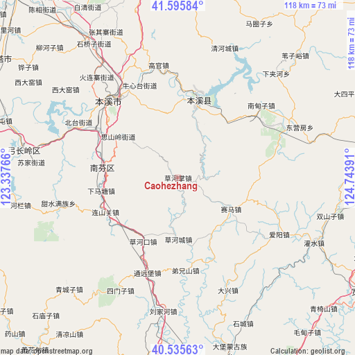
| Upper-left | 41.59584°, | 123.33766° |
| Center: | 41.06787°, | 124.04078° |
| Lower-right: | 40.53563°, | 124.74391° |
| Map W x H: | 117.9×117.9 km | = 73.3×73.3mi |
| max Lat: | 53.31946° ⇑10.7% North |
| Caohezhang: | 41.06787° |
| min Lat: | ⇓89.3% South 18.22056° |
| min Long | Caohezhang | max Long |
| 75.07348° | 124.04078° | 134.28917° |
| W 93.8%⇐ | ⇒6.2% E |
Elevation
Elevation of Caohezhang is 343 m = 1125 ft, and this is 141.8 m = 465 ft below average elevation for this country.
| Max E: |
5622 m = 18445 ft | 34% |
| Avg. | 484.8 m = 1591 ft | |
| Caohezhang | 343 m = 1125 ft | |
Min E: |
-3 m = -10 ft | 66% |
See also: China elevation on elevation.city.
Geographical zone
Caohezhang is located in North temperate zone (between Tropic of Cancer and the Arctic Circle). Distance of this Northern Tropic circle is 1960.4 km =1218.1 mi to South.| Distance of | km | miles | from Caohezhang |
|---|---|---|---|
| North Pole | 5440.7 | 3380.7 | to North |
| Arctic Circle | 2834.9 | 1761.5 | to North |
| Tropic Cancer | 1960.4 | 1218.1 | to South |
| Equator | 4566.3 | 2837.4 | to South |


Nearby cities:
15 places around Caohezhang: (largest is in red/bold)
• Benxi
33.7 km =20.9 mi,  316°
316°
• Caohekou
23.9 km =14.9 mi,  208°
208°
• Dongyingfang
43.7 km =27.2 mi,  67°
67°
• Gongchangling
49.8 km =30.9 mi,  276°
276°
• Guanyinge
28 km =17.4 mi,  12°
12°
• Jianchang
41.4 km =25.7 mi,  60°
60°
• Liujiahe
44.6 km =27.7 mi,  186°
186°
• Nandianzi
36.4 km =22.6 mi,  49°
49°
• Qingchengzi
52.4 km =32.6 mi,  224°
224°
• Qinghecheng
45.7 km =28.4 mi,  19°
19°
• Simenzi
41.7 km =25.9 mi, 206°
• Tianshifu
33.5 km =20.8 mi, 51°
• Tongyuanpu
32.4 km =20.1 mi,  198°
198°
• Weiziyu
56.4 km =35 mi,  43°
43°
• Xiaoshi
26.4 km =16.4 mi, 14°
Sources, notices
• [Note1] Compared only with cities in China existing in our database
• [Src1] Map data: © OpenStreetMap contributors (CC-BY-SA)
• [Src2] Other city data from geonames.org with taken over terms of usage.
• [Src3] Geographical zone / Annual Mean Temperature by Robert A. Rohde @ Wikipedia
